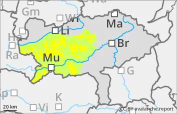
Persistent weak layer problem! Take particular care in gullies and bowls in northern and eastern exposures!
The avalanche risk is assessed as moderate above the tree line and low below. There is still a persistent weak layer problem in the northern and eastern exposures. In addition, fresh pillows of wind drifted snow could form in the same aspects, which can be triggered by low additional loads. Medium-sized slab avalanches are possible when breaking through the weak old snowpack. The danger areas are mainly located in the transition from little to more snow as well as behind terrain edges and in the entrance area of gullies and bowls. The avalanche prone locations are sometimes difficult to recognise due to a few centimetres of new fallen snow.
Snowpack
The total snow depth is well below average. With the southerly wind, thin pillows of wind drifted snow have formed in northern aspects. These cover a very variable and mostly hardness old snowpack. There is significantly more snow in shady gullies and bowls than on sunny slopes, some of which are partly bare up to 2000 metres. In the northern and eastern exposures, the snowpack is still weakened by layers with faceted crystals and floating snow (persistent weak layer problem!).
Tendency
An Italian low will bring snowfall and rain on Wednesday. The snowfall level will be between 800 and 1500 metres above sea level. There will be hardly any precipitation on the northern side of the Alps. The southerly wind will ease in the west. The avalanche risk increases slightly with the new fallen snow.
Danger level
treeline
Avalanche Problem
Persistent weak layer
Treeline
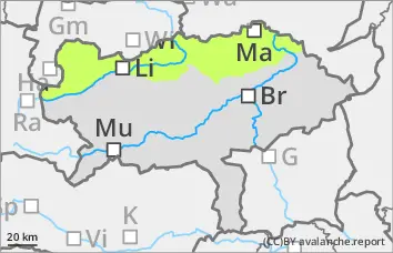
Low avalanche danger, but persistent weak layer problems in the northern and eastern exposures!
The avalanche risk is low. In the northern and eastern exposures, there is still a persistent weak layer problem at altitudes above the tree line. In addition, fresh pillows of wind drifted snow have formed with the strong south-westerly wind. In steep terrain, these can be triggered in a few places. However, even if the old snowpack is torn through, the avalanches usually remain small. In general, the risk of entrainment, falling and injury outweighs the risk of burial. However, be careful in the area of terrain traps.
Snowpack
There is still significantly less snow than average. A thin, partly bound snowpack covers a very variable and mostly hard old snowpack. There is significantly more snow in shady gullies and bowls than on sunny slopes, some of which are partly bare up to 2000 metres. In the northern and eastern exposures, the snowpack is still weakened by layers with faceted crystals and floating snow (persistent weak layer problem!).
Tendency
The avalanche risk is not expected to increase.
In the night to Thursday, some new fallen snow will only fall in the eastern northern Alps, in the west it will remain mostly precipitation-free. During the day there will still be some clouds and fog in windless conditions. Apart from a few snowflakes, no significant new fallen snow is expected.
Danger level
treeline
Avalanche Problem
Persistent weak layer
Treeline
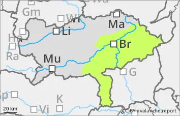
Low avalanche danger with mostly little snow.
The avalanche risk is low. In extremely steep gullies or bowls on shady slopes, the triggering of small slab avalanches cannot be completely ruled out.
Snowpack
There is still significantly less snow than average. A thin, partly bound snowpack covers a very variable and mostly hard old snowpack. In shady gullies and bowls, the connection between the bound snowpack and the old snowpack is sometimes poor. In addition, angular shapes can weaken the snow base, fundament.
Tendency
The risk of avalanches will increase slightly with the snowfall on Thursday night.
During the day, there will still be some clouds and fog in windless conditions. Apart from a few snowflakes, no significant new fallen snow is expected.