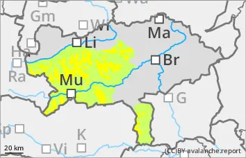
Persistent weak layer problem! Take particular care in gullies and bowls in northern and eastern exposures!
The avalanche risk is assessed as moderate above the tree line and low below. The snow layering is still very weak, especially in the northern and eastern sectors. Here, avalanches can be triggered by even small additional loads and can reach medium size when breaking through the weak old snowpack. In some cases, there is a thin, bound layer from the last snowfall. The danger areas are mainly located in the transition from little to more snow as well as behind terrain edges and in the entrance area of gullies and bowls. Some of the avalanche prone locations are difficult to recognise.
Snowpack
The total snow depth is well below average. A thin, partly bound snowpack covers a very variable and mostly hard old snowpack. There is significantly more snow in shady gullies and bowls than on sunny slopes, which are partly bare up to 2000 metres. In the northern and eastern exposures, the snowpack is still weakened by layers with faceted crystals and floating snow (persistent weak layer problem!).
Tendency
An Italian low will bring snowfall and rain on Wednesday. The snowfall level will be between 800 and 1500 metres above sea level. There will be hardly any precipitation on the northern side of the Alps. The southerly wind will ease in the west. The avalanche risk increases slightly with the new fallen snow.
Danger level
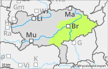
Low avalanche danger with mostly little snow.
The avalanche risk is low. In extremely steep gullies or bowls on shady slopes, the triggering of small slab avalanches cannot be completely ruled out.
Snowpack
There is still significantly less snow than average. A thin, partly bound snowpack covers a very variable and mostly hard old snowpack. In shady gullies and bowls, the connection between the bound snowpack and the old snowpack is sometimes poor. In addition, angular shapes can weaken the snow base, fundament.
Tendency
An Italian low will bring snowfall and rain on Wednesday. The snowfall level will be between 800 and 1500 metres above sea level. The southerly wind is easing. With the new fallen snow, the avalanche risk increases slightly on Wednesday afternoon.
Danger level
treeline
Avalanche Problem
Persistent weak layer
Treeline
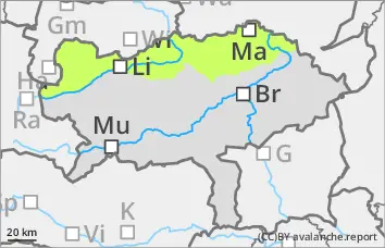
Low avalanche danger, but persistent weak layer problems in the northern and eastern exposures!
The avalanche risk is low. In the northern and eastern exposures, there is still a persistent weak layer problem at altitudes above the tree line. In steep terrain, small slab avalanches can be triggered in a few places by individual winter sports enthusiasts. Avalanche prone locations are mainly at the entrance to on shady slopes and bowls as well as behind terrain edges. In general, the risk of being swept away, falling and injury outweighs the risk of burial. However, be careful in the area of terrain traps.
Snowpack
There is still significantly less snow than average. A thin, partly bound snowpack covers a very variable and mostly hard old snowpack. There is significantly more snow in shady gullies and bowls than on sunny slopes, some of which are partly bare up to 2000 metres. In the northern and eastern exposures, the snowpack is still weakened by layers with faceted crystals and floating snow (persistent weak layer problem!).
Tendency
An Italian low will bring snowfall and rain to the south on Wednesday. The snowfall level will be between 800 and 1500 metres above sea level. There will be hardly any precipitation on the northern side of the Alps. The southerly wind will ease in the west. No change in the avalanche danger is expected.