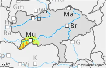
15 to 30 cm of new fallen snow with wind on a weak old snowpack! Tricky situation for winter sports in open terrain!
15 to 30 cm of new fallen snow was deposited on a soft snow surface or surface hoar under moderate to strong winds. Medium-sized slab avalanches can be triggered in some places. Naturally triggered avalanches and remote triggering are also possible. Fractures can tear through the poorly built-up persistent weak layer. The avalanche prone locations are barely recognisable and should be assessed defensively. Take particular care in the transition from a little to a lot of snow and in the blown-in entrance areas of gullies and bowls.
Snowpack
Due to 15 to 30 cm of new fallen snow and moderate to strong winds, fresh drift snow packs have formed, some of which have been deposited on surface hoar or a soft snow surface. Fractures usually occur at the transition from new fallen snow to old snowpack or within the old snowpack. Between melt-freeze crusts, the old snowpack consists of deep rime and angular forms.
Tendency
On Friday, there will be a brief intermittent high with some sunny spells. In the afternoon, it will start to get cloudy again from the west.
The avalanche danger decreases slightly.
Danger level
treeline
Avalanche Problem
Persistent weak layer
Treeline
Wind slab
Treeline
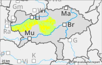
Persistent weak layer problem in northern and eastern sectors, covered by fresh wind slab!
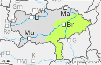
The avalanche risk is assessed as moderate above the tree line and low below. There is still a persistent weak layer problem in the northern and eastern exposures. In addition, fresh pillows of wind drifted snow could form, which can be triggered as a small slab avalanche with a small additional load. Medium-sized slab avalanches are also possible when breaking through the weak old snowpack. The danger areas are mainly located in the transition from little to more snow as well as behind terrain edges and in the entrance area of gullies and bowls. The avalanche prone locations are sometimes difficult to recognise due to a few centimetres of new fallen snow.
Snowpack
The total snow depth is well below average. A few centimetres of new fallen snow and strong winds have created fresh pillows of wind drifted snow, some of which have been deposited on surface hoar or a soft snow surface. These cover a very variable and mostly hardness old snowpack. There is significantly more snow in shady gullies and bowls than on sunny slopes. In the northern and eastern exposures, the snowpack is still weakened by layers with faceted crystals and floating snow (persistent weak layer problem!).
Tendency
On Friday, there will be a brief intermittent high with some sunny spells. In the afternoon, it will start to get cloudy again from the west.
No change in the avalanche danger is expected.
Danger level
treeline
Avalanche Problem
Wind slab
Treeline
Persistent weak layer
Treeline
Fresh wind slab forms snow slab on weak old snowpack! Tricky situation for winter sports in open terrain!
With new fallen snow and strong winds, fresh drift snow packs are deposited on a soft snow surface or surface hoar, especially in western, northern and eastern aspects. Medium-sized slab avalanches can be triggered in some places. Fractures in the fresh wind slab can tear through into the poorly built-up persistent weak layer. In northern and eastern aspects, remote triggering is also possible in the persistent weak layer. The avalanche prone locations in the persistent weak layer are barely recognisable and should be assessed defensively. Caution should be exercised in particular in the transition from a little to a lot of snow and in the blown-in entrance areas of gullies and bowls.
Snowpack
The snowpack is highly variable and areas with little snow alternate with considerable snowdrift accumulations. Due to 10 to 20 cm of new fallen snow and moderate to strong winds, fresh drift snow packs have formed, some of which have been deposited on surface hoar or a soft snow surface. Fractures usually occur near the crust, which forms the transition to the mostly angular old snowpack. Under this crust, the old snowpack consists of deep rime and angular forms, which are interspersed with further crusts in areas with more snow.
Tendency
On Friday, there will be a brief intermittent high with some sunny spells. In the afternoon, it will start to get cloudy again from the west.
No change in the avalanche danger is expected.
Danger level
treeline
Avalanche Problem
Persistent weak layer
Treeline
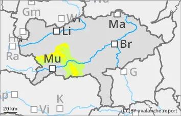
Low avalanche danger, but persistent weak layer problems in the northern and eastern exposures!
The avalanche risk is low. In the northern and eastern exposures, there is still a persistent weak layer problem at altitudes above the tree line. In addition, the strong to stormy southerly winds have created fresh pillows of wind drifted snow. In steep terrain, these can be triggered in a few places. However, the avalanches remain small even if they tear through to the old snowpack. In general, the risk of entrainment, falling and injury outweighs the risk of burial. However, be careful in the area of terrain traps.
Snowpack
There is still significantly less snow than average. A thin, partly bound snowpack covers a very variable and mostly hard old snowpack. There is significantly more snow in shady gullies and bowls than on sunny slopes, some of which are partly bare up to 2000 metres. In the northern and eastern exposures, the snowpack is still weakened by layers with faceted crystals and floating snow (persistent weak layer problem!).
Tendency
On Friday, there will be a brief intermittent high with some sunny spells. In the afternoon, it will become cloudy again from the west. Some new fallen snow is expected in the north-west in the night to Saturday.
No change in the avalanche risk is expected on Friday.
Danger level
treeline
Avalanche Problem
Persistent weak layer
Treeline
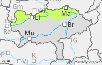
Low avalanche danger with mostly little snow.
The avalanche risk is low. In a few places, especially in locations above the tree line, snowdrift accumulations can be triggered as small slab avalanches in steep gullies and bowls. Avalanche prone locations and icy areas can be covered with a thin layer of fresh snow. Small, wet slides cannot be ruled out at altitudes below 1500 metres.
Snowpack
There is still significantly less snow than average. A thin, partly bound snowpack covers a very variable and mostly hard old snowpack. In shady gullies and bowls, the connection between the bound snowpack and the old snowpack is sometimes poor. In addition, angular shapes can weaken the snow base, fundament.
Tendency
On Friday, there will be a brief intermittent high with some sunny spells. In the afternoon, it will start to get cloudy again from the west.
No change in the avalanche danger is expected.