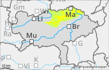
Fresh wind slab above 2000 m, wet snow problem at medium altitudes!
The avalanche risk is moderate at higher altitudes from early on. Fresh pillows of wind drifted snow can be triggered as small slab avalanches in some places on ridgelines and summits. In extremely steep, shady areas, avalanches can also tear through persistent weak layers and reach medium size. Below 2000 metres, the avalanche risk increases to moderate during the day as the temperature rises. Due to the rain or wet snowfall from the previous day, slopes that have not yet been discharged can sometimes spontaneously break off and reach medium size.
Snowpack
Outgoing longwave radiation at night is limited. The recent precipitation at a high snowfall level has brought additional moisture into the snowpack up to medium altitudes. The rise in temperature leads to additional moistening of the snowpack during the day. Some of the wind slab is still poorly bonded to the old snowpack in the ridgeline and summit areas. As it warms up, the snowpack settles during the day. In very shady areas above 2000 m, the snowpack still has cold reserves and some weak layers in the persistent weak layer are still prone to triggering.
Tendency
The wind slab problem will decrease, but the wet snow problem will persist on Sunday.
On Sunday, the sky will be mostly partly cloudy and it will remain very mild. From Monday, dense clouds and sunshine will alternate frequently and it will remain dry in most regions.
EARLIER Danger level
2200m
Avalanche Problem
Wet snow
2200m
Persistent weak layer
2200m
LATER Danger level
Avalanche Problem
Wet snow
Persistent weak layer
2200m
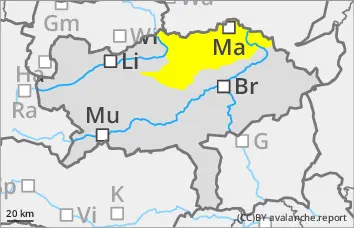
Avalanche danger increases to moderate (level 2) during the day!
The avalanche risk is initially low and increases to moderate during the daytime changes. From terrain that has not yet been discharged, spontaneous or wet to moist medium loose snow or slab avalanches triggered by additional loads are possible in all aspects. In extremely steep, shady areas above 2200 m, small to medium-sized slab avalanches can still be triggered in persistent weak layers. Small fresh snowdrift accumulations can still occur in the ridgelines and summits.
Snowpack
Outgoing longwave radiation at night is limited. The recent precipitation at a high snowfall level has brought additional moisture into the snowpack up to high altitudes. The rise in temperature leads to additional moistening of the snowpack at all altitudes. The wind slab settles quickly as it warms up. In very shady areas above 2200 metres, the snowpack still has reserves of cold and in some cases persistent weak layers in the old snow that are prone to triggering.
Tendency
On Sunday, the sky will be mostly cloudy and it will remain very mild. The wet snow problem will persist. From Monday, dense clouds and sunshine will alternate frequently and it will remain dry in most regions.
Danger level
Avalanche Problem
Wet snow
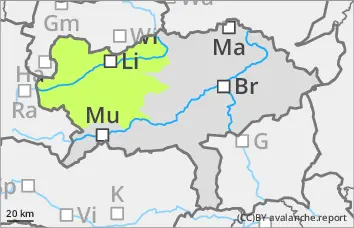
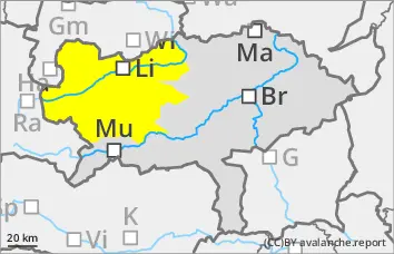
Low avalanche danger, occasional small wet snow slides!
The avalanche risk is low. As the day warms up, small wet snow slides may occur occasionally, especially from multiple starting zones that have not yet been fully discharged. The risk of being swept away and falling should be taken into account.
Snowpack
The thin snowpack will become damp in all areas during the day changes and lose firmness. Only in very shady areas above 2000 metres does the snowpack still have small cold reserves and isolated weak layers in the persistent weak layer.
In general, there is very little snow and the depletion is progressing.
Tendency
On Sunday, the sky will be mostly cloudy and it will remain very mild. The wet snow problem will persist. From Monday, dense clouds and sunshine will alternate frequently, but it will remain dry.