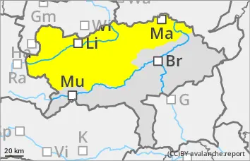
Fresh wind slabs at higher elevations, some spontaneous wet snow avalanches below!
The avalanche risk is moderate. Wet loose snow and slab avalanches are possible in all aspects on slopes below around 1800 metres that have not yet been discharged with the arrival of rain. The avalanches can occur spontaneously or be triggered by individuals and reach medium size. At higher altitudes (usually above 1800 m), fresh snowdrift accumulations prone to triggering form, the number and size of which increase with altitude. Slab avalanches in fresh wind slab usually remain small. In extremely steep, shady areas above 2200 m, small to medium-sized slab avalanches can occasionally be triggered by individuals (persistent weak layer problem).
Snowpack
Outgoing longwave radiation at night is limited; a thin crust of melted snow can only form on the snow surface at the summit level. With the onset of rain, the snowpack becomes increasingly soaked. In the west, the snowfall level is sometimes above 1800 metres, in the east often below. Small-scale snowdrift accumulations form at higher altitudes. There are weak layers within the wind slab and in the transition to the old snowpack. In very shady areas above 2200 m, the snowpack still has cold reserves and some weak layers in the persistent weak layer that are prone to triggering.
Tendency
On Saturday, sunny weather will return during the daytime changes and it will become milder again. The wind slab problem will decrease, but wet snow avalanches are still to be expected.
Danger level
Avalanche Problem
Wet snow
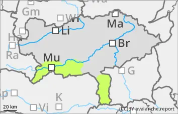
Low avalanche danger, occasional small wet snow slides!
The avalanche risk is low. Rainfall can occasionally lead to small wet snow slides, especially from multiple starting zones that have not yet been fully discharged. The risk of being swept away and falling should be taken into account.
Snowpack
Overnight outgoing longwave radiation can cause the snow surface to consolidate somewhat. The thin snowpack will become damp in all areas during the daytime changes, and with rainfall it will also become wet in places and lose firmness. Only in very shady areas above 2000 metres does the snowpack still have small cold reserves and occasional weak layers in the persistent weak layer.
In general, there is very little snow and the depletion is progressing.
Tendency
It will be milder again on Saturday. After clearing clouds and sunshine, the danger of wet slides will increase slightly again during the day changes.