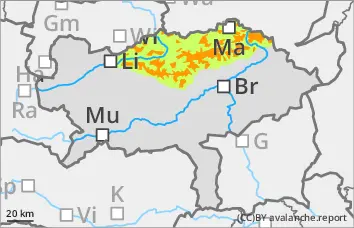
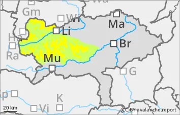
The avalanche danger is still assessed as considerable (level 3) above 1500 metres. The persistent wind is leading to extensive snowdrift accumulations. These are prone to triggering, especially above the tree line. The main problem is the wind slab. The avalanche prone locations are adjacent to ridgelines and distant from ridgelines. Slopes from east to south to south-west are particularly affected. They are mainly located in gullies, bowls and behind terrain edges. The drift snow layer can be triggered as a snow slab by individual winter sports enthusiasts as a medium-sized avalanche. Sporadic loose snow avalanches are also possible. Small wet slides are possible at low altitude.
Snowpack
The cold temperatures at high altitude are preserving the snow layering. A lot of snow has been transported in the last few days. The wind slab has not yet been able to settle. The snowdrift accumulations have been deposited above the tree line on a partly still weak old snowpack. Weak layers can be found in the bound layer or in the transition to the old snow, at higher altitudes in places still in the persistent weak layer (faceted crystals in the area of crusts).
Tendency
The wind slab problem will continue.
With a north-westerly current, dense clouds will continue to accumulate along the northern side of the Alps, and it may snow heavily on Tuesday and Wednesday, especially between the Schladminger Tauern and the Totes Gebirge. It will only snow a little to the east, and not at all in the south with clear clouds and strong winds.
Danger level
treeline
Avalanche Problem
Wind slab
Treeline
Beware of fresh wind slab!
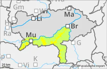
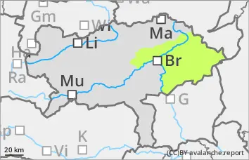
The avalanche risk is moderate above the tree line. Fresh snowdrift accumulations can be triggered as small to medium-sized avalanches by individual winter sports enthusiasts in all aspects. The avalanche prone locations are mainly in gullies, bowls and behind terrain edges.
Snowpack
Fresh snowdrift accumulations were often deposited on a sufficiently stable old snowpack above the tree line. Weak layers can be found in the bound layer or in the transition to the persistent weak layer, in some places still in the old snow at higher altitudes.
Tendency
The wind slab problem remains.
With a north-westerly current, dense clouds will continue to accumulate along the northern side of the Alps, and there may be heavy snowfall on Tuesday and Wednesday, especially between the Schladminger Tauern and the Totes Gebirge. It will only snow a little to the east, but not at all in the south with clear clouds and strong winds.
Danger level
treeline
Avalanche Problem
Wind slab
Treeline
Take particular care in the east and south sectors!
The avalanche danger is rated as moderate above the tree line. The stormy wind has formed fresh wind slabs that are easily recognisable. Above the tree line, the fresh wind slab can easily be triggered as a snow slab. Typically, medium avalanches are expected to be triggered. The avalanche prone locations are adjacent to ridgelines as well as distant from ridgelines and in steep gullies and bowls. Loose snow avalanches are possible from steep rocky and rugged terrain.
Snowpack
The strong to stormy wind has continued to work the snow. The wind slab is usually quite hard. Weak layers are to be expected within the drift snow layer. The old snowpack is mostly hard and the snowpack near the ground is weakened by floating snow.
Tendency
With a north-westerly current, dense clouds will continue to accumulate along the northern side of the Alps, with the possibility of heavy snowfall on Tuesday and Wednesday, especially between the Schladminger Tauern and the Totes Gebirge. It will only snow a little to the east, and not at all in the south with clear clouds and strong winds.
An increase in avalanche danger is expected.
Danger level
Fresh pillows of wind drifted snow!
The avalanche danger is assessed as low. Fresh pillows of wind drifted snow can be triggered as a slide.
Snowpack
A few centimetres of new fallen snow or wind slabs have been deposited on a hardness of old snowpack. There is generally little snow.
Tendency
No significant change in the avalanche risk is expected. With a north-westerly current, dense clouds will continue to accumulate along the northern side of the Alps, with the possibility of heavy snowfall on Tuesday and Wednesday, especially between the Schladminger Tauern and the Totes Gebirge. It will only snow a little to the east, and not at all in the south with clear clouds and strong winds.