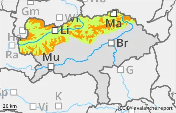
The avalanche danger above 1500 metres is rated as "considerable". New fallen snow and persistent wind lead to extensive snowdrift accumulations. These are prone to triggering, especially above the tree line. The avalanche prone locations are adjacent to ridgelines and distant from ridgelines. They are mainly located in gullies, bowls and behind terrain edges down to forest aisles. Aspects from east to south to south-west are particularly affected. The drift snow layer can be triggered by individual winter sports enthusiasts, usually in the form of medium-sized avalanches. Naturally triggered avalanches are also possible in isolated cases.
Snowpack
A lot of snow has fallen in the last few days. Up to 40 cm of new or wind slab snow will be added on Tuesday. The snowdrift accumulations are deposited on a mostly stable old snowpack. There are weak layers in the drift snow and occasionally, in shady high altitudes, also in the snow base, fundament (persistent weak layer problem).
Tendency
On Wednesday, the wind will shift to the north-east. Mostly clouds, but no more new fallen snow. The wind slab problem remains.
Danger level
treeline
Avalanche Problem
Wind slab
Treeline
Persistent weak layer
2000m
Fresh wind slab in the high altitudes!
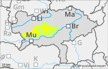
The avalanche danger is rated as "moderate" above the tree line. The stormy wind forms fresh wind slabs, which are usually easily recognisable. Above the tree line, the fresh wind slab can easily be triggered as a slab avalanche. Medium-sized avalanches are typically expected. The avalanche prone locations are on lee slopes both adjacent to ridgelines and distant from ridgelines and in steep gullies and bowls.
Snowpack
The strong to stormy winds have continued to work the snow and have led to smaller, fresh snowdrift accumulations. The wind slab is usually quite hard. Weak layers are to be expected within the drift snow layer. The old snowpack is mostly hard and the snowpack near the ground is weakened by floating snow in shady high areas.
Tendency
On Wednesday, the wind will shift to the north-east. Mostly clouds, but no more new fallen snow. The wind slab problem remains.
Danger level
1500m
Avalanche Problem
Wind slab
1500m
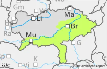
Low avalanche danger, but avoid fresh pillows of wind drifted snow!
The avalanche danger is assessed as "low". Nevertheless, fresh pillows of wind drifted snow can occasionally be triggered as small slab avalanches.
Snowpack
Stormy winds repeatedly lead to the formation of fresh pillows of wind drifted snow, which are deposited on a hard old snowpack and are usually sufficiently bonded to it. There is generally little snow.
Tendency
On Wednesday, the wind will shift to the north-east. Mostly cloudy, but no more new fallen snow. The avalanche risk remains low.