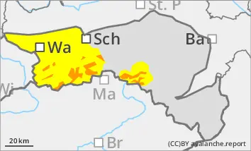
Prone to triggering wind slab snow in the higher elevations! Beginning of wet snow problems at lower altitudes.
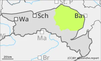
The avalanche risk above the tree line is rated as "considerable". Stormy north-westerly winds create fresh drift snow packs in the east and south sectors, which in many places can be triggered by individual winter sports enthusiasts as medium slab avalanches. Spontaneous wet snow avalanches and smaller gliding avalanches can occur at lower altitudes.
Snowpack
The connection between the drift snow layer and the old snowpack is often insufficient. Prone to triggering weak layers in the form of snow deposits of varying hardness also exist in the bound layer in places. In shady high altitudes, the old snowpack is unfavourably structured in places with crusts and embedded faceted crystals.
With increasing moisture penetration, the snowpack at lower altitudes increasingly loses firmness and stability and can also start to glide snow on steep grass and forest slopes.
Tendency
High pressure influence and massive warming at high altitude from midday on Wednesday. The zero-degree level will rise towards 3000 metres in the evening. The wet snow problem is a priority at all altitudes and will increase briefly!
Danger level
Avalanche Problem
Wet snow
Wind slab
1000m
Wet snow problems at lower altitudes. Occasional prone to triggering wind slab in the higher elevations!
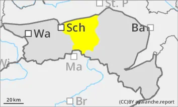
The avalanche risk is moderate (level 2). Spontaneous wet snow avalanches and smaller gliding avalanches can occur in steep slope zones, including forest slopes or on embankments. Due to persistent stormy north-westerly winds, isolated fresh drift snow packs are prone to triggering. Especially in the north-east to south-east sectors, slab avalanches can be triggered in a few places by individual winter sports enthusiasts.
Snowpack
With increasing moisture penetration, the snowpack loses stability at lower elevations and can also start to glide snow on steep grass and forest slopes. The connection between fresh snow packs and the old snowpack is sometimes insufficient. In shady high altitudes, the old snowpack with faceted crystals is unfavourably structured in places.
Tendency
With the influence of high pressure and a strong rise in temperatures on Wednesday, the wet snow problem will increase!
Danger level
treeline
Avalanche Problem
Wind slab
Treeline
Wet snow
Treeline
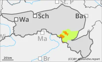
More new fallen snow than expected! Beware of prone to triggering wind slabs at higher elevations!
The avalanche risk is considerable above the tree line. New fallen snow and stormy winds create avalanche prone locations in the form of fresh wind slabs. These continue to grow with persistent stormy north-westerly winds, especially at higher altitudes. In some places, especially in steep entrance areas, gullies and bowls, these can already be triggered by individual winter sports enthusiasts as slab avalanches.
At lower altitudes, spontaneous wet snow slides from very steep areas and smaller gliding avalanches cannot be ruled out with rain.
Snowpack
Stormy north-westerly winds and up to 25 cm of new fallen snow are increasingly forming fresh snowdrift accumulations. The connection between the drift snow packs and the old snowpack is insufficient in places. Prone to triggering weak layers in the form of snow deposits of varying hardness also exist in places in the bound layer. In shady high altitudes, the old snowpack is unfavourably structured in places with crusts and embedded faceted crystals.
With increasing moisture penetration, the snowpack loses stability at lower altitudes and can also start to glide snow on steep grass and forest slopes.
Tendency
High pressure influence and massive warming at high altitude from midday on Wednesday. The zero-degree level will rise towards 3000 metres in the evening. The wet snow problem is a priority at all altitudes and will increase briefly!
Danger level
1400m
Avalanche Problem
Wind slab
1400m
Wet snow
1400m
Prone to triggering wind slab snow in the higher elevations! Beginning of wet snow problems at lower altitudes.
The avalanche danger is rated as "moderate" above the tree line. Stormy north-westerly winds create fresh drift snow packs, which in some places can be triggered by individual winter sports enthusiasts as medium slab avalanches. Spontaneous wet snow slides and smaller gliding avalanches can occur at lower elevations.
Snowpack
Stormy north-westerly winds and some new fallen snow are increasingly forming fresh snowdrift accumulations. The connection between the drift snow packs and the old snowpack is insufficient in places. Prone to triggering weak layers in the form of snow deposits of varying hardness also exist in places in the bound layer. In shady high altitudes, the old snowpack is unfavourably structured in places with crusts and embedded faceted crystals.
With increasing moisture penetration, the snowpack loses stability at lower altitudes and can also start to glide snow on steep grass and forest slopes.
Tendency
With the influence of high pressure and a strong rise in temperatures on Wednesday, the wet snow problem will increase!
Danger level
Avalanche Problem
Wet snow
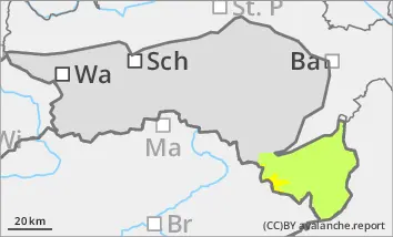
Wet snow problem with rain
The avalanche risk is moderate (level 2). Spontaneous wet snow avalanches and smaller gliding avalanches can occur in steep slope zones, including forest slopes or on embankments. Due to persistent stormy north-westerly winds, isolated fresh drift snow packs are prone to triggering. Especially in the north-east to south-east sectors, slab avalanches can be triggered in a few places by individual winter sports enthusiasts.
Snowpack
With increasing moisture penetration, the snowpack loses stability at lower elevations and can also start to glide snow on steep grass and forest slopes. The connection between fresh snow packs and the old snowpack is sometimes insufficient. In shady high altitudes, the old snowpack with faceted crystals is unfavourably structured in places.
Tendency
With the influence of high pressure and a strong rise in temperatures on Wednesday, the wet snow problem will continue!