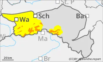
Prone to triggering wind slab snow in the higher elevations! Beginning of wet snow problems at lower altitudes.
The avalanche risk above the tree line is rated as "considerable". Stormy north-westerly winds create fresh drift snow packs in the east and south sectors, which in many places can be triggered by individual winter sports enthusiasts as medium slab avalanches. Spontaneous wet snow avalanches and smaller gliding avalanches can occur at lower altitudes.
Snowpack
Stormy north-westerly winds form fresh wind slabs. The connection between the drift snow packs and the old snowpack is not yet sufficient in places. At shady high altitudes, the old snowpack is unfavourably structured in places with crusts and embedded faceted crystals. With the arrival of rain, the snowpack at lower altitudes loses stability and can also start to glide snow on steep grassy slopes.
Tendency
The weather will deteriorate again on Tuesday night, with heavy rain and snowfall starting again after midnight at the latest. Above around 1000 metres, a good 10 to 20 cm of new fallen snow is possible by midday on Tuesday. It will remain stormy! The risk of avalanches is increasing!
Danger level
Avalanche Problem
Wet snow
Wind slab
1100m
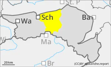
Wet snow problems at lower altitudes. Occasional prone to triggering wind slab in the higher elevations!
The avalanche risk is moderate (level 2). Spontaneous wet snow avalanches and smaller gliding avalanches can occur in steep slope zones, including forest slopes or on embankments. Due to persistent stormy north-westerly winds, isolated fresh drift snow packs are prone to triggering. Especially in the north-east to south-east sectors, slab avalanches can be triggered in a few places by individual winter sports enthusiasts.
Snowpack
With increasing moisture penetration, the snowpack loses stability at lower elevations and can also start to glide snow on steep grass and forest slopes. The connection between fresh snow packs and the old snowpack is sometimes insufficient. In shady high altitudes, the old snowpack with faceted crystals is unfavourably structured in places.
Tendency
The weather will deteriorate again on Tuesday night, with rain and snowfall starting again after midnight at the latest. It remains stormy! The risk of avalanches increases slightly!
Danger level
treeline
Avalanche Problem
Wind slab
Treeline
Wet snow
Treeline
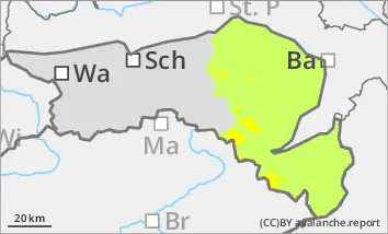
Still prone to triggering wind slabs in gullies and bowls! Beginning of wet snow problems at lower elevations.
The avalanche danger is rated as "moderate" above the tree line. Stormy north-westerly winds create fresh drift snow packs, which in some places can be triggered by individual winter sports enthusiasts as medium slab avalanches. Spontaneous wet snow slides and smaller gliding avalanches can occur at lower elevations.
Snowpack
Stormy north-westerly winds form fresh wind slabs. The connection between the drift snow packs and the old snowpack is not yet sufficient in places. In shady high altitudes, the old snowpack is unfavourably structured in places with crusts and embedded angular crystals. As it warms up, the snowpack at lower altitudes loses stability and can start to glide snow on steep grassy slopes.
Tendency
The weather will deteriorate again in the night to Tuesday, with heavier rain and snowfall temporarily setting in after midnight at the latest. Above approx. 1000 m, 10 - 15 cm of new fallen snow is possible by midday on Tuesday. It will remain stormy! The risk of avalanches is increasing!