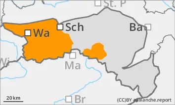
Wet snow problem at the bottom, wind slab problem at the top
The avalanche danger is predominantly categorised as considerable. Due to some intense snowfall and wind, there will be additional wind slab avalanches in the higher elevations. The triggering of medium to rarely large slab avalanches is possible to likely on some steep slopes due to low additional loads. Due to the local old snow problem, the snowpack can tear through to deeper layers. Above the tree line, medium to sometimes large spontaneous slab avalanches are possible. Spontaneous wet snow avalanches are to be expected below the snowfall level due to heavy rainfall.
Snowpack
In the last 24 hours, up to 40 cm of new fallen snow, the largest amounts in the Ybbstal Alps, fell with strongly changing snowfall levels. Stormy winds led to extensive drifting. The connection between the drift snow layer and the old snowpack is often insufficient. Prone to triggering weak layers in the form of snow deposits of varying hardness also exist in the bound layer in places. At shady high altitudes, the old snowpack is unfavourably structured in places with crusts and embedded faceted crystals. At medium altitudes, the snow is moist or wet. Warming and incoming radiation lead to soaking, decreasing firmness and destabilisation up to higher altitudes. The snowpack can start to glide snow on steep grass and forest slopes.
Tendency
The avalanche situation remains tense.
Danger level
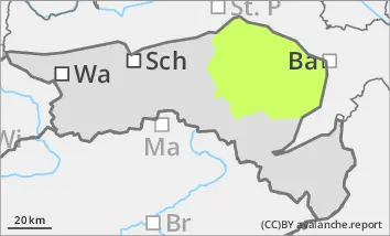
treeline
Avalanche Problem
Wind slab
Treeline
Wet snow
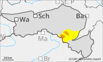
Wet snow problem at the bottom, wind slab problem at the top
The avalanche danger is predominantly categorised as considerable. Due to some intense snowfall and wind, there will be additional wind slab avalanches in the higher elevations. The triggering of medium to rarely large slab avalanches is possible to likely on some steep slopes due to low additional loads. Due to the local old snow problem, the snowpack can tear through to deeper layers. Above the tree line, medium to sometimes large spontaneous slab avalanches are possible. Spontaneous wet snow avalanches are to be expected below the snowfall level due to heavy rainfall.
Snowpack
In the last 24 hours, up to 30 cm of new fallen snow fell with a strongly changing snowfall level. Stormy winds led to extensive drifting. The connection between the drift snow layer and the old snowpack is often insufficient. There are also prone to triggering weak layers in the bound layer in the form of soft snow deposits. At shady high altitudes, the old snowpack is unfavourably structured in places with crusts and embedded faceted crystals. At medium altitudes, the snow is moist or wet. Warming and incoming radiation lead to soaking, decreasing firmness and destabilisation up to higher altitudes. The snowpack can start to glide snow on steep grass and forest slopes.
Tendency
The avalanche situation remains tense.
Danger level
Avalanche Problem
Wet snow
Wet snow problems at lower altitudes. Occasional prone to triggering wind slab in the higher elevations!
The avalanche risk is moderate (level 2). Spontaneous wet snow avalanches and smaller gliding avalanches can occur in steep slope zones, including forest slopes or on embankments. Due to persistent stormy north-westerly winds, isolated fresh drift snow packs are prone to triggering. Especially in the north-east to south-east sectors, slab avalanches can be triggered in a few places by individual winter sports enthusiasts.
Snowpack
In many locations, the snowpack was soaked by rain and often dissolved completely. With a highly variable snowfall level, some new fallen snow fell at higher altitudes, which became increasingly moistened and lost firmness during the day.
Existing fresh snow packs are only occasionally prone to triggering (on shady slopes) and settle during the daytime changes.
Tendency
The avalanche situation remains tense.
Danger level
1500m
Avalanche Problem
Wind slab
1500m
Wet snow
Treeline
Wet snow
Treeline
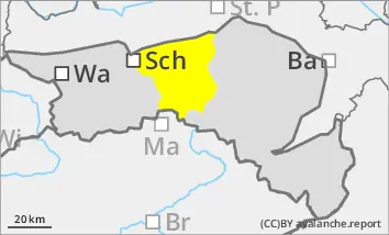
Prone to triggering wind slab snow in the higher elevations! Beginning of wet snow problems at lower altitudes.
The avalanche danger is predominantly categorised as considerable. Due to some intense snowfall and wind, there will be additional wind slab avalanches in the higher elevations. The triggering of medium to rarely large slab avalanches is possible to likely on some steep slopes due to low additional loads. Due to the local old snow problem, the snowpack can tear through to deeper layers. Above the tree line, medium to sometimes large spontaneous slab avalanches are possible. Spontaneous wet snow avalanches are to be expected below the snowfall level due to heavy rainfall.
Snowpack
Between 10 and 20 cm of new fallen snow has fallen in the last 24 hours. Precipitation centred on the Wechsel region. The snow will quickly become wet on Wednesday up to the summit regions.
Tendency
The avalanche situation remains tense.
Danger level
Avalanche Problem
Wet snow
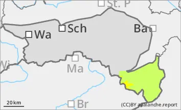
Wet snow problem with rain
The avalanche risk is moderate (level 2). Spontaneous wet snow avalanches and smaller gliding avalanches can occur in steep slope zones, including forest slopes or on embankments. Due to persistent stormy north-westerly winds, isolated fresh drift snow packs are prone to triggering. Especially in the north-east to south-east sectors, slab avalanches can be triggered in a few places by individual winter sports enthusiasts.
Snowpack
With increasing moisture penetration, the snowpack loses stability at lower elevations and can also start to glide snow on steep grass and forest slopes. The connection between fresh snow packs and the old snowpack is sometimes insufficient. In shady high altitudes, the old snowpack with faceted crystals is unfavourably structured in places.
Tendency
With the influence of high pressure and a strong rise in temperatures on Wednesday, the wet snow problem will continue! The avalanche situation remains tense.