Large amounts of fresh snow and drifts blanket a weak old snowpack. Avalanches can easily be triggered by one single winter sports enthusiast in all aspects, and then grow to large size. Danger zones are numerous, occur also near the timberline. For activities outside secured zones, conditions are extremely dangerous. Remote triggerings and naturally triggered avalanches continue to be anticipated. Particularly in starting zones which have not yet discharged, they can in isolated cases be very large-sized and plummet down to low altitude zones. Exposed transportation routes can be placed at risk. Rain impact at low and intermediate altitudes will lead to the snowpack softening up and thus, to increased frequency of naturally triggered avalanches.
Snowpack
All in all, 20-30cm of fresh snow was registered on Saturday from the warm front. The large amounts of fresh snow from the last few days have been repeatedly transported in varying directions, generating far-reaching snowdrift accumulations. These are often blanketed over and difficult to recognize. Bonding to the generally weak snowpack is weak. Several large and very large sized avalanche releases due to artificial triggerings, remote triggerings and provoked by winter sports enthusiasts confirm just how trigger-sensitive the snowpack is.
Tendency
The early part of the week will bring rising temperatures and only minor amounts of precipitation. Particularly at low and intermediate altitudes, wet-snow and glide-snow avalanches can be increasingly expected. The situation remains quite treacherous for winter sports enthusiasts.
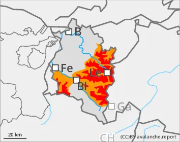
Danger level
1600m
Avalanche Problem
New snow
1600m
Persistent weak layer
2000m
New snow
1600m
Wet snow
1800m
Naturally triggered avalanches still expected
Dangerous avalanche situation persists
Large amounts of fresh snow and drifts blanket a weak old snowpack. Avalanches can easily be triggered by one single winter sports enthusiast in all aspects, and then grow to large size. Danger zones are numerous, occur also near the timberline. For activities outside secured zones, conditions are extremely dangerous. Remote triggerings and naturally triggered avalanches continue to be anticipated. Particularly in starting zones which have not yet discharged, they can in isolated cases be very large-sized and plummet down to low altitude zones. Exposed transportation routes can be placed at risk. Rain impact at low and intermediate altitudes will lead to the snowpack softening up and thus, to increased frequency of naturally triggered avalanches.
Snowpack
All in all, 20-30cm of fresh snow was registered on Saturday from the warm front. The large amounts of fresh snow from the last few days have been repeatedly transported in varying directions, generating far-reaching snowdrift accumulations. These are often blanketed over and difficult to recognize. Bonding to the generally weak snowpack is weak. Several large and very large sized avalanche releases due to artificial triggerings, remote triggerings and provoked by winter sports enthusiasts confirm just how trigger-sensitive the snowpack is.
Tendency
The early part of the week will bring rising temperatures and only minor amounts of precipitation. Particularly at low and intermediate altitudes, wet-snow and glide-snow avalanches can be increasingly expected. The situation remains quite treacherous for winter sports enthusiasts.
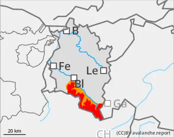
Danger level
2000m
Avalanche Problem
New snow
2000m
Persistent weak layer
1800m
New snow
2000m
Wet snow
1800m
Danger of slab avalanches at high altitudes, wet loose-snow avalanches at lower avalanches
Avalanches can be triggered by one single winter sports enthusiast. Danger zones occur on steep slopes in all aspects, behind drops in the landscape and in wind-loaded gullies and bowls. Frequency and spread of avalanche prone locations increase with ascending altitude. Whumpf noises and fractures which appear when treading upon the snowpack are alarm signals. Activities in outlying terrain demand cautious assessment of the terrain and careful evaluation of the dangers. The inexperienced should not leave secured ski runs. Rain impact is leading to a softening of the snowpack at low and intermediate altitudes; this can lead to naturally triggered, small-to-medium sized avalanches. Zones with glide cracks should be avoided.
Snowpack
All in all, 20-30cm of fresh snow was registered on Saturday from the warm front. The large amounts of fresh snow from the last few days have been repeatedly transported in varying directions, generating far-reaching snowdrift accumulations. These are often blanketed over and difficult to recognize. Bonding to the generally weak snowpack is moderate-to-weak. At intermediate altitudes the snowpack is already moist.
Tendency
The early part of the week will bring rising temperatures and only minor amounts of precipitation. Particularly at low and intermediate altitudes, wet-snow and glide-snow avalanches can be increasingly expected.
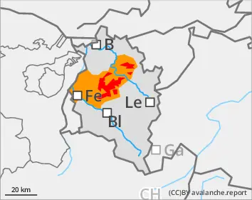
Danger level
1600m
Avalanche Problem
New snow
1600m
New snow
1600m
Wet snow
1600m
Danger of slab avalanches down to the treeline, wet loose-snow avalanches below there
Avalanches can be triggered even by one sole winter sports enthusiast. Danger zones occur on very steep slopes in all aspects, behind drops in the terrain and in wind-loaded gullies and bowls, particularly at the upper limits of the timberline. Rainfall and higher temperatures are softening the snowpack at low and intermediate altitudes, which can lead to naturally triggered medium-sized loose-snow avalanches. Zones where there are glide cracks on the surface should be avoided.
Snowpack
All in all, about 20cm of fresh snowfall was registered on Saturday from the warm front, falling as rain at lower altitudes. The snowpack surface at intermediate altitudes is already wet in many places.
Tendency
The early part of the week will bring rising temperatures and only minor amounts of precipitation. Particularly at low and intermediate altitudes, wet-snow and glide-snow avalanches can be increasingly expected.