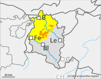
Large amounts of fresh snow and drifts blanket a weak old snowpack. Avalanches can easily be triggered by one single winter sports enthusiast in all aspects, and then grow to large size. Danger zones are numerous, occur also near the timberline. For activities outside secured zones, conditions are extremely dangerous. Remote triggerings and naturally triggered avalanches continue to be anticipated. Particularly in starting zones which have not yet discharged, they can in isolated cases be very large-sized and plummet down to low altitude zones. Exposed transportation routes can be placed at risk. Rain impact at low and intermediate altitudes will lead to the snowpack softening up and thus, to increased frequency of naturally triggered avalanches.
Snowpack
By Saturday evening, an additional 20-30cm of fresh snow is expected, locally more. The large amounts of fresh snow from the last few days have been repeatedly transported in varying directions, generating far-reaching snowdrift accumulations. These are now often blanketed over and difficult to recognize. Bonding to the usually weak snowpack is weak. Several large and very large sized avalanche releases due to artificial triggerings, remote triggerings and provoked by winter sports enthusiasts confirm just how trigger-sensitive the snowpack is.
Tendency
The danger of naturally triggered avalanches is slowly diminishing. Due to rising temperatures and first-time solar radiation, the situation remains treacherous for winter sports enthusiasts. Wet-snow and glide-snow avalanches can be increasingly expected, especially at low and intermediate altitudes.
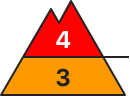
Danger level
1600m
Avalanche Problem
New snow
1600m
Persistent weak layer
2000m
New snow
1600m
Wet snow
1800m
Naturally triggered avalanches still expected
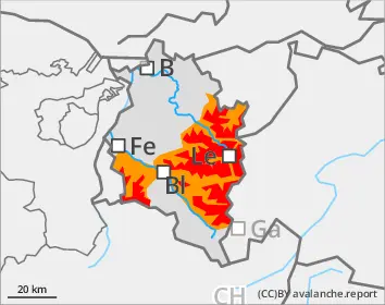
Dangerous avalanche situation persists
Large amounts of fresh snow and drifts blanket a weak old snowpack. Avalanches can easily be triggered by one single winter sports enthusiast in all aspects, and then grow to large size. Danger zones are numerous, occur also near the timberline. For activities outside secured zones, conditions are extremely dangerous. Remote triggerings and naturally triggered avalanches continue to be anticipated. Particularly in starting zones which have not yet discharged, they can in isolated cases be very large-sized and plummet down to low altitude zones. Exposed transportation routes can be placed at risk. Rain impact at low and intermediate altitudes will lead to the snowpack softening up and thus, to increased frequency of naturally triggered avalanches.
Snowpack
By Saturday evening, an additional 20-30cm of fresh snow is expected, locally more. The large amounts of fresh snow from the last few days have been repeatedly transported in varying directions, generating far-reaching snowdrift accumulations. These are now often blanketed over and difficult to recognize. Bonding to the usually weak snowpack is weak. Several large and very large sized avalanche releases due to artificial triggerings, remote triggerings and provoked by winter sports enthusiasts confirm just how trigger-sensitive the snowpack is.
Tendency
The danger of naturally triggered avalanches is slowly diminishing. Due to rising temperatures and first-time solar radiation, the situation remains treacherous for winter sports enthusiasts. Wet-snow and glide-snow avalanches can be increasingly expected, especially at low and intermediate altitudes.
Danger level
treeline
Avalanche Problem
Wind slab
Treeline
Persistent weak layer
1800m
Wet snow
1800m
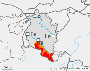
Considerable avalanche danger above the timberline
Avalanches can be triggered by one single winter sports enthusiast. Danger zones occur on steep slopes in all aspects, behind drops in the landscape and in wind-loaded gullies and bowls. Frequency and spread of avalanche prone locations increase with ascending altitude. Whumpf noises and fractures which appear when treading upon the snowpack are alarm signals. Activities in outlying terrain demand cautious assessment of the terrain and careful evaluation of the dangers. The inexperienced should not leave secured ski runs. Rain impact is leading to a softening of the snowpack at low and intermediate altitudes; this can lead to naturally triggered, small-to-medium sized avalanches. Zones with glide cracks should be avoided.
Snowpack
By Saturday evening, an additional 10-20cm of fresh snow is anticipated. The amounts of fresh fallen snow are continually being transported in varying directions, new snowdrift accumulations generated, but they are difficult to recognize since constantly getting blanketed with fresh snowfall. Fresh snow and drifts have settled slightly, but bonding to the unfavorable snowpack is usually weak.
Tendency
Particularly at low and intermediate altitudes, increasingly frequent wet-snow and glide-snow avalanches can be expected.