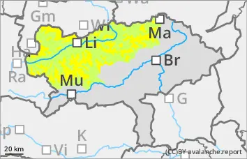
The avalanche danger is moderate above the tree line (level 2) and low below. In particular, older snowdrift accumulations in the east and north sectors, especially behind ridgelines, terrain edges and in gullies and bowls, can be triggered as medium slab avalanches even by low additional loads.
In addition, small, spontaneous wet snow avalanches are to be expected at medium altitudes and, on sunny slopes, also at high altitudes.
Snowpack
The snow cover, snowpack was able to settle somewhat due to the warmth. The snow became moist at medium altitudes.
At high altitudes, wind slab snow lies on angular forms in the northern and eastern exposures. Weak layers are mainly found between drift and new fallen snow and the old snowpack (unstable layer of faceted crystals). In the foundation of the snow cover, kinetic metamorphism (floating snow) weakens the stability.
Tendency
On Friday and at the weekend, the weather will be quite sunny north of the main Alpine ridge, with low, high fog-like clouds accumulating more frequently from the south. The wind will shift to southeast to southwest.
The risk of avalanches is decreasing.
Danger level
Avalanche Problem
Wet snow
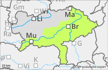
Low avalanche danger, but isolated wet snow slides!
The avalanche risk is low. However, small, spontaneous wet snow slides can occur at low altitudes, e.g. from wooded areas and also at higher altitudes on the sunny slopes.
In the extremely steep north-facing gullies at high altitudes, a snow slab release cannot be ruled out.
Snowpack
The persistent weak layer problem is easing due to the warming, but the snow can become wet and therefore unstable at medium altitudes and on sunny slopes.
Tendency
Slowly but surely, the temperature is also dropping again at all altitudes. The avalanche risk remains low.