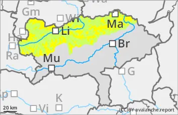
Moderate avalanche danger at higher altitudes. Even a single person can trigger a slab avalanche, and naturally triggered avalanches are also possible in isolated cases!
The avalanche danger is moderate above the tree line (level 2) and low below. In particular, older snowdrift accumulations, but also bonded snow in all aspects can be triggered as medium slab avalanches in some places, especially behind ridgelines, terrain edges and in gullies and bowls, even with a small additional load. Sporadic spontaneous slab avalanches are also possible.
In addition, small, spontaneous wet snow avalanches can be expected at lower elevations and also at higher elevations on the sunny side.
Snowpack
Up to 70 cm of new fallen snow has fallen since Thursday. The snow has been transported to the eastern sectors by stormy westerly to north-westerly winds over a large area, but locally all cardinal points and also forest aisles below the tree line can be affected. As a result of the warming, a bound snow layer will also develop in places where there was previously unbound powder. Weak layers are mainly found between drift and new fallen snow and the old snowpack (unstable layer of faceted crystals). In the foundation of the snow cover, kinetic metamorphism (floating snow) weakens the stability.
Tendency
With the influence of high pressure, the coming days will be trouble-free. Occasionally, dense clouds will cover the sun, but rain or snowfall is not in sight for the time being. Slowly but surely, the temperature will drop again at all altitudes.
The risk of avalanches is decreasing.
Danger level
treeline
Avalanche Problem
Persistent weak layer
Treeline
Wet snow
2000m
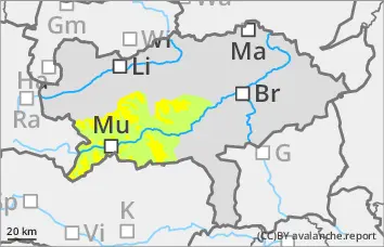
Moderate avalanche danger above the tree line. Even a single person can trigger a slab avalanche!
The avalanche danger is moderate above the tree line (level 2) and low below. In particular, older snowdrift accumulations, but also bonded snow in all aspects can be triggered as a small to medium slab avalanche in some places, especially behind ridgelines, terrain edges and in gullies and bowls, even with a small additional load.
In addition, small, spontaneous wet snow avalanches can be expected at lower altitudes and also at higher altitudes on the sunny side.
Snowpack
Up to 30 cm of new fallen snow has fallen since Thursday. The snow has been transported to the eastern sectors by stormy westerly to north-westerly winds. Due to the warming, a bound snow layer is now developing in places where there was previously unbound powder. Weak layers are mainly found between drift and new fallen snow and the old snowpack (unstable layer of faceted crystals). In the foundation of the snow cover, kinetic metamorphism (floating snow) weakens the stability.
Warming can cause the snow cover to become unstable at lower elevations and, on sunny slopes, also at higher elevations and slide off as a small loose snow avalanche.
Tendency
With the influence of high pressure, the coming days will be trouble-free. Occasionally, dense clouds will cover the sun, but rain or snowfall is not in sight for the time being. Slowly but surely, the temperature will drop again at all altitudes.
The risk of avalanches is decreasing.
Danger level
2000m
Avalanche Problem
Wet snow
2000m
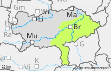
Low avalanche danger, but isolated wet snow slides!
The avalanche risk is low. However, small, spontaneous wet snow slides can occur at low altitudes, e.g. from wooded areas and also at higher altitudes on sunny slopes.
Snowpack
The persistent weak layer problem is easing due to the warming, but the snow can become wet and therefore unstable at low altitudes and on sunny slopes.
Tendency
With the influence of high pressure, the coming days will be trouble-free. Occasionally, dense clouds will cover the sun, but rain or snowfall is not in sight for the time being. Slowly but surely, the temperature will drop again at all altitudes.
The risk of avalanches remains low.