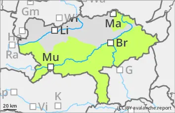
Danger level
 | 1900m |
|  |
|  |

![]()
Pay attention to fresh wind slab
There is a moderate avalanche risk above 1900 metres. With new fallen snow and a prone-to-triggering westerly wind, prone-to-triggering snowdrift accumulations can continue to form. These can be triggered by individuals as small to medium-sized slab avalanches, especially behind broad ridges and ridgelines in northern, eastern and southern aspects as well as in gullies and bowls. The avalanche prone locations are easily recognisable with sufficient visibility. Often, some of the snow has covered over the exposed areas, so beware of the risk of injury.
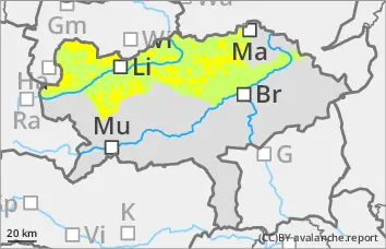
Snowpack
The existing snow cover, snowpack is characterised by the strong winds of the last few days. Fresh snowdrift accumulations may form on New Year's Eve with around 15 cm of new fallen snow and persistently strong winds. In many places, they will cover soft layers in the transition to persistent weak layers or existing drift snow packs. The connection between them is poor. On the shady slopes, there are sometimes weak layers of faceted crystals in the old snow foundation. The composition and thickness of the snow cover, snowpack varies greatly in a small area. There is often insufficient old snowpack.
Tendency
It will be very cold again on Friday and next weekend with a fresh supply of cold air, and it will remain windy. However, there is unlikely to be any new fallen snow. No significant change in the avalanche situation with wind and cold, wind slab remains the main problem.