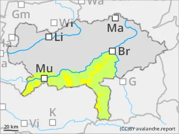
The avalanche is above the treeline moderate and below that low. New snow and northerly winds fresh danger spots are forming with snowdrift. These are prone to triggering especially in the expositions north via east till west. They can be triggered by individuals as slab avalanche. The danger spots are increasing during the course of the day. The new snow can be triggered as spontaneous loose-snow avalanche from extremely steep areas with few winds. In places of steep areas wet loose-snow avalanches are possible.
Snowpack
By Saturday evening, 10-30 cm of new snow will fall, and locally even more. Depending on wind influences, driftsnow deposits of varying thickness will form over the course of the day, often sufficiently bonding with the existing old snowpack. With increasing altitude, weak layers (isolated) will form soft layers in the near-surface old snowpack (on the shady slopes) and primarily in the bonded layer. In some places, rain may lead to a loss of snowpack strength.
Tendency
Precipitation will intensify again overnight into Sunday, and during the day the showers will retreat to the northern areas, while the south will experience favorable weather conditions from midday onwards due to the northerly foehn winds. The avalanche danger will increase slightly depending on the amount of new snow.
Danger level
treeline
Avalanche Problem
Wind slab
Treeline
Persistent weak layer
2000m
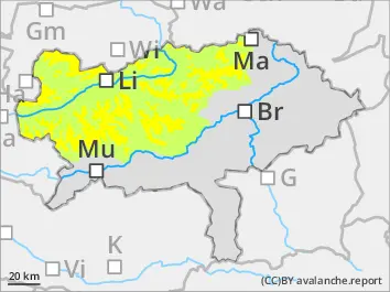
The avalanche is above the treeline moderate and below that low. New snow and northerly winds fresh danger spots are forming with snowdrift. These are prone to triggering especially in the expositions north via east till west. They can be triggered by individuals as slab avalanche. The danger spots are increasing during the course of the day. The new snow can be triggered as spontaneous loose-snow avalanche from extremely steep areas with few winds. In places of steep areas wet loose-snow avalanches are possible.
Snowpack
By Saturday evening, 10-30 cm of new snow will fall, and locally even more. Depending on wind influences, driftsnow deposits of varying thickness will form over the course of the day, often sufficiently bonding with the existing old snowpack. With increasing altitude, weak layers (isolated) will form soft layers in the near-surface old snowpack (on the shady slopes) and primarily in the bonded layer. In some places, rain may lead to a loss of snowpack strength.
Tendency
Precipitation will intensify again overnight into Sunday, and during the day the showers will retreat to the northern areas, while the south will experience favorable weather conditions from midday onwards due to the northerly foehn winds. On Monday snowfall in the northern Alps more, the sowline sinks to 700 m. Driftsnow due to increasing winds and cooling!
Danger level
treeline
Avalanche Problem
Wind slab
Treeline
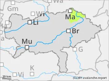
Fresh danger spots during the course of the day due to newsnow and wind
The avalanche danger is low. Due to new snow and increasing winds during the course of the day snowdrift packs which are prone to triggering are forming. These can be triggered as small slab avalanches.
Snowpack
The new snow lands partially on bare soil, only in shady high areas it lands on a crusted old snow cover. Weak layers which can cause slab avalanches are found predominantly within a fresh bonded layer.