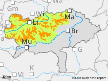
Considerable avalanche danger - the amount of danger spots is increasing due to fresh snowdrift!
The avalanche is above the treeline considerable and below that low. Snowdrift accumulations are forming danger spots which are increasing with height. They are found especially in the expositions west via east till south. They can be triggered by small additional loads as slab avalanches. In places avalanches can be triggered within the old snow in high shady areas. Spontaneous gliding- or wet loose-snow avalanches coming from steep smooth slopes are possible.
Snowpack
Fresh snowdrift accumulations are placed on top of an old snow cover with which it is often sufficiently bonded. Soft layers within the fresh cover or in shady slopes within the old snow near the surface can function as weak layers. On Sunday around 30 can new snow is called which will form - due to strong wind influence - unevenly amounts of snowdrift accumulations. In places rain respectively wetness from the ground leads to a loss of moisture within the snowcover.
Tendency
On Monday the temperatures will fall and the snowline will be around 900 m. Precipitation, predominantly in Nordstau areas are dominating. Partially stormy northern winds. Snowdrift problem is increasing due to higher amounts of new snow!
Danger level
treeline
Avalanche Problem
Wind slab
Treeline
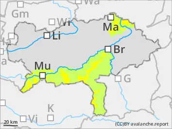
Moderate avalanche danger above the treeline - snowdrift is prone to triggering!
The avalanche is above the treeline moderate and below that low. Snowdrift accumulations are forming danger spots which are increasing with height. They are found in gullies and bowls especially in the expositions west via east till south. They can be triggered by small additional loads as slab avalanches.
Snowpack
Fresh snowdrift accumulations are placed on top of an old snow cover with which it is often sufficiently bonded or on bare soil. Soft layers within the fresh cover or in shady slopes within the old snow near the surface can function as weak layers. On Sunday around 20 cm new snow is called which will form - due to strong wind influence - unevenly amounts of snowdrift accumulations. In places rain respectively wetness from the ground leads to a loss of moisture within the snowcover.
Tendency
On Monday the temperatures will fall and the snowline will be around 900 m. Precipitation, predominantly in Nordstau areas are dominating. Partially stormy northern winds. Snowdrift problem is increasing due to higher amounts of new snow!