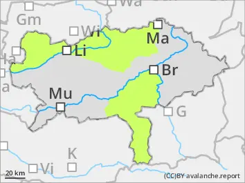
Danger level
 | 1800m |
|  |
|  |

![]()
Consider snowdrift in higher altitudes!
Avalanche danger above 1.800 m moderate and below 1.800 m low. The main problem is fresh snowdrift which is partially covered and hard to spot due to poor visibility. Danger spots are located in the expositions northwest via north to east. Small to medium slab avalanches can be triggered by an individuals in steep slopes. Caution behind ridgelines. Small spontaneous loose-snow avalanches coming from extremely steep terrain are possible. Gliding-snow avalanches coming from steep grassy terrain cannot be ruled out.
Snowpack
Since Thursday it had 15 to 30 cm new snow in some places even more. The southern winds drifted the new snow to the northern sectors. In high altitudes the bonding to the mostly hard stable old snow cover is partially insufficient. Soft layers in the transition area are weak layers. In extremely steep terrain the loose new snow can loose its stability and the diffuse radiation must not be underestimated. In medium altitudes the new snow landed on top of bare areas.
Tendency
On Monday cold air masses are coming to the eastern Alps with a strong northern current. Stormy weather in the mountains. Some snow showers in the north and many clouds. Better weather in the south side of the Alps. Fresh snowdrift in eastern via southern and western slopes due to winds.