Danger level
 | 1800m |
|  |
|  |

![]()
Caution fresh snowdrift!
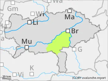
Avalanche danger in high altitudes is moderate and below that low. The main problem is fresh snowdrift which is partially covered and hard to spot due to poor visibility. Danger spots are located in the expositions west via north to southeast. Small to medium slab avalanches can be triggered by an individuals in steep slopes. Caution behind ridgelines. Small spontaneous loose-snow avalanches coming from extremely steep, rocky terrain are possible. Gliding-snow avalanches coming from steep grassy terrain cannot be ruled out.
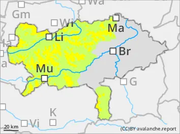
Snowpack
The new snow could already settle a little bit. Only little new snow is called. Strong to stormy winds will drift the loose snow and will be prone to triggering. Soft layers in the transition area are weak layers. In extremely steep terrain the loose new snow can loose its stability and the diffuse radiation must not be underestimated. In medium altitudes the new snow landed on top of bare areas and has no base.
Tendency
Monday night will be already clear and will be the coldest. During the day the high pressure system will cause clear skies in the mountains, temperatures get milder and the wind will weaken. Snowdrift will begin to settle and spontaneous loose-snow avalanches are possible due to sun radiation.