Wet avalanches are already expected in the morning.
The avalanche danger increases from moderate to considerable during the daytime changes below 2500 metres.
Small and medium, damp and wet loose snow avalanches and snow slabs are to be expected in all aspects below around 2500 metres. Wet avalanches can also be triggered by winter sports enthusiasts.
A few small gliding avalanches are to be expected on typical slopes.
In a few places above 2200 m, snow slabs can also be triggered in persistent weak layers, especially on west-, north- and east-facing slopes, and also on the south side in the high Alps. Avalanche prone locations are difficult to recognise.
Snowpack
The snow on the surface is often sticky to wet from early in the morning, and the snow is also moistened on the north side up to around 2600 metres. Pure sunny slopes are (almost) isothermal up to high altitudes and moist right down to the ground. At high altitudes on shady slopes, the old snowpack contains angular forms and deep rime. Fractures are most likely to occur on one of the uppermost crusts and only rarely in the floating snow close to the ground. In some cases, the snow also glides off the ground.
Tendency
A spring situation with melt-freeze crust in the morning and firn during the daytime changes. On shady slopes, the persistent weak layer problem remains.
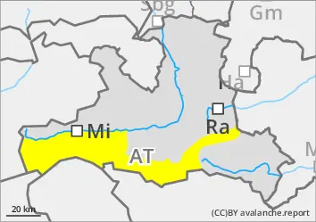
EARLIER Danger level
2200m
Avalanche Problem
Persistent weak layer
2200m
Wet snow
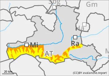
LATER Danger level
Avalanche Problem
Wet snow
Persistent weak layer
2200m
Wet avalanches are already expected in the morning.
The avalanche risk is moderate.
Small and medium-sized wet loose snow avalanches and snow slabs can be expected in all aspects, especially in the morning rain or afternoon sunshine. Wet avalanches can also be triggered by winter sports enthusiasts.
Small gliding avalanches are to be expected on typical slopes.
In a few places above 2200 metres, snow slabs can also be triggered in the extended northern sector in weak persistent weak layers.
Snowpack
The snow on the surface is often sticky to wet from early in the morning. Pure sunny slopes are (almost) isothermal up to high altitudes and moist right down to the ground. At high altitudes on shady slopes, the old snowpack has angular shapes and deep rime. Breakage or sliding of the snow is most likely to occur on one of the uppermost crusts and only rarely in the floating snow close to the ground. In a few places, the snow also glides off the ground.
Tendency
It's a classic spring situation with melt-freeze crust and firn.
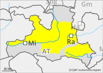
EARLIER Danger level
LATER Danger level
Avalanche Problem
Wet snow
During the daytime changes, wet avalanches are more likely to be triggered.
Avalanche conditions are usually favourable in the morning after a clear night. During the daytime changes, the propensity to trigger wet avalanches increases, especially on extremely steep sunny slopes. Wet avalanches can mainly come from multiple starting zones that have not yet been fully discharged. These are usually small but can easily be triggered by individual winter sports enthusiasts. Tours should be ended in good time.
Snowpack
The outgoing longwave radiation at night is sometimes quite good. The snow surface freezes and softens quickly. Sun and warmth lead to increasing soaking of the snowpack during the day changes.
Shady slopes with little snow above around 1800 m: The lower part of the snowpack is faceted.
Tendency
Little change.
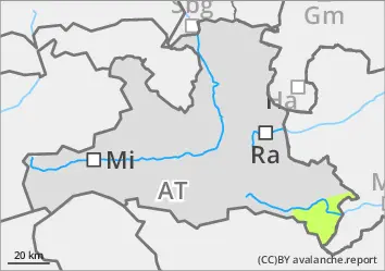
EARLIER Danger level
Avalanche Problem
Wet snow
LATER Danger level
Avalanche Problem
Wet snow
Few small wet avalanches.
The avalanche risk is low.
With a little rain, small, wet loose snow avalanches are to be expected. Gliding avalanches may also occur occasionally.
Snowpack
The snowpack is damp to wet. The snow cover is thinning rapidly.