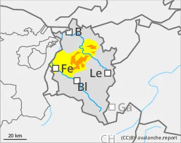
Caution: considerable avalanche danger widespread at high altitudes
Avalanche danger above 2000m is considerable, below that altitude danger is moderate. Fresh snow and far-reaching snowdrift accumulations are easily triggered particularly on shady slopes. Slabs can be triggered by minimum additional loading and grow to medium-to-large sized releases. Settling noises when treading the snowpack can indicate imminent danger. Danger zones occur in wind-loaded steep terrain, behind sharp drops in the landscape, in gullies and bowls. The snowdrift accumulations generated over the last few days are blanketed by fresher snow, thus impossible to recognize. On very steep sunny grass-covered slopes, glide-snow avalanches can slide away and grow to medium size.
Snowpack
Over the last few days there has been lots of fresh snowfall, often transported by intermittently strong-to-stormy NW winds, frequently generating large, trigger-sensitive snowdrift accumulations. On Saturday night and during the day on Sunday, additional generally small-sized trigger-sensitive snowdrifts will accumulate due to the forecast 10cm of fresh snowfall. Inside the fresh snow and drifts of recent days there are weak intermediate layers and graupel. The old snowpack is well consolidated and compact by and large.
Tendency
As a result of fresh snow and winds, avalanche danger will increase starting on Monday.
Danger level
2000m
Avalanche Problem
New snow
2000m
New snow
2000m
Persistent weak layer
2200m
Gliding snow
2000m
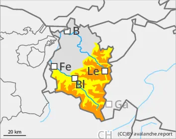
Caution: at high altitudes, considerable avalanche danger widespread
Avalanche danger above 2000m is considerable, below that altitude danger is moderate. Fresh snow and far-reaching snowdrift accumulations are easily triggered particularly on shady slopes. Slabs can be triggered by minimum additional loading and grow to medium-to-large sized releases. Settling noises when treading the snowpack and fractures on the surface can indicate imminent danger. Danger zones occur in wind-loaded steep terrain, behind sharp drops in the landscape, in gullies and bowls. The snowdrift accumulations generated over the last few days are blanketed by fresher snow, thus impossible to recognize. On very steep sunny grass-covered slopes, glide-snow avalanches can slide away and grow to medium size.
Snowpack
Over the last few days there has been lots of fresh snowfall, often transported by intermittently strong-to-stormy NW winds, frequently generating large, trigger-sensitive snowdrift accumulations. On Saturday night and during the day on Sunday, additional generally small-sized trigger-sensitive snowdrifts will accumulate due to the forecast 10cm of fresh snowfall. Inside the fresh snow and drifts of recent days there are weak intermediate layers and graupel. Beneath a melt-freeze crust in the uppermost third of the snowpack there is often a layer of faceted crystals. The mid-section of the snowpack is well consolidated and compact widespread by and large, on shady slopes at high altitudes, it blankets a poorly structured old snowpack fundament.
Tendency
As a result of fresh snow and winds, avalanche danger will increase starting on Monday. Depending on amounts of snowfall, Danger Level 4 could be reached on Tuesday.
Danger level
1600m
Avalanche Problem
New snow
1600m
New snow
1600m
Gliding snow
2000m
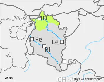
Fresh snow and drifts often prone to triggering, particularly on shady slopes
Avalanche danger above 1600m is moderate, below that altitude danger is low. Fresh snow and far-reaching snowdrift accumulations are easily triggered in all aspects in many places. Slabs can be triggered by minimum additional loading and grow to medium-to-large sized releases. Danger zones occur in wind-loaded steep terrain, behind sharp drops in the landscape, in gullies and bowls. The snowdrift accumulations generated over the last few days are blanketed by fresher snow, thus impossible to recognize. On very steep sunny grass-covered slopes, glide-snow avalanches can slide away, mostly of small size.
Snowpack
In the last few days there has been a lot of fresh snowfall, often stormy NW winds transported the fresh fallen snow, generating large-sized trigger-sensitive snowdrift accumulations in many places. On Saturday night and during the day on Sunday, additional generally small-sized trigger-sensitive snowdrifts will accumulate due to the forecast 10cm of fresh snowfall.
Tendency
As a result of fresh snow and winds, avalanche danger will increase starting on Monday.