Avalanche danger above the treeline is considerable, below that altitude danger is low. Fresh snowdrift accumulations are easily triggered. Slabs can be triggered by minimum additional loading and grow to medium-sized releases. Settling noises when treading the snowpack and fractures on the surface can indicate imminent danger. Danger zones occur in wind-loaded steep terrain, behind sharp drops in the landscape, in gullies and bowls. The snowdrift accumulations generated on Sunday are blanketed by fresher snow, thus impossible to recognize. On very steep sunny grass-covered slopes, glide-snow avalanches can slide away and grow to medium size.
Snowpack
The fresh snow and snowdrifts from Wednesday and Thursday have been able to settle and consolidate somewhat. On steep sunny slopes the fresh snow is already slightly moist and encrusted. As a result of northerly winds, 5-15cm of fresh snow was registered on Sunday, generating mostly small-sized trigger-sensitive snowdrift accumulations. These will expand further on Monday daytime due to strong NW winds and fresh snowfall. In the uppermost third of the snowpack are weak intermediate layers and graupel. The old snowpack is generally well consolidated and compact.
Tendency
As a result of fresh snow and wind, avalanche danger will increase on Monday night.
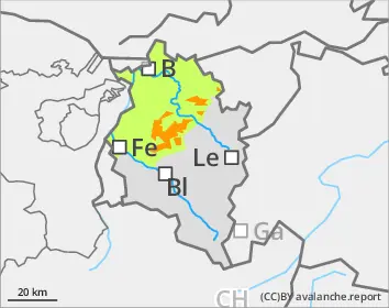
Danger level
treeline
Avalanche Problem
Wind slab
Treeline
Persistent weak layer
2200m
Gliding snow
2000m
Main problem: freshly generated drifts
Avalanche danger above the treeline is considerable, below that altitude danger is low. Fresh snowdrift accumulations are easily triggered. Slabs can be triggered by minimum additional loading and grow to medium-sized releases. Settling noises when treading the snowpack and fractures on the surface can indicate imminent danger. Danger zones occur in wind-loaded steep terrain, behind sharp drops in the landscape, in gullies and bowls. The snowdrift accumulations generated on Sunday are blanketed by fresher snow, thus impossible to recognize. On very steep sunny grass-covered slopes, glide-snow avalanches can slide away and grow to medium size.
Snowpack
The fresh snow and snowdrifts from Wednesday and Thursday have been able to settle and consolidate somewhat. On steep sunny slopes the fresh snow is already slightly moist and encrusted. As a result of northerly winds, 5-15cm of fresh snow was registered on Sunday, generating mostly small-sized trigger-sensitive snowdrift accumulations. These will expand further on Monday daytime due to strong NW winds and fresh snowfall. In the uppermost third of the snowpack are weak intermediate layers and graupel. The old snowpack is generally well consolidated and compact. On high-altitude shady slopes these layers cover a poorly-structured old snowpack fundament.
Tendency
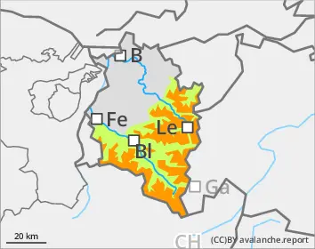
As a result of fresh snow and wind, avalanche danger will increase significantly on Monday night.