Slab avalanches can be triggered very easily in gullies!
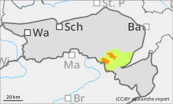
Above 1400 metres there is a considerable avalanche risk (level 3). The stormy winds have created prone-to-triggering snowdrift accumulations in almost all aspects, which can be triggered by individual winter sports enthusiasts in some places as medium-sized, occasionally also as large slab avalanches. prone-to-triggering. The avalanche prone locations are adjacent to ridgelines and far from ridgelines. They are mainly located in steep gullies and behind terrain edges. Take particular care in the transition from a little to a lot of snow. Avalanche prone locations can be covered by fresh pillows of wind drifted snow. Defensive behaviour is recommended for winter sports in open terrain.
Snowpack
From Wednesday evening to Saturday morning, 30 to 50 cm of new fallen snow above around 1400 m fell under the influence of strong winds. The snow was transported into gullies and bowls by the stormy north to north-westerly winds. As a result, snowdrift accumulations have formed, some of which are not to be underestimated. There are weak layers within the drift snow packs and in the transition to the old snowpack. Fresh snowdrift accumulations are deposited above the tree line on top of the already prone to triggering snow packs.
Tendency
The risk of avalanches remains considerable at higher altitudes.
With a northerly high-altitude current, dense clouds will accumulate along the northern side of the Alps for almost the entire Holy Week, with frequent snowfall. The north to north-westerly wind will also remain brisk to stormy, leading to the formation of new snow packs.
Danger level
1200m
Avalanche Problem
Wind slab
1200m
Wind slab
1200m
Beware of prone to triggering wind slabs! Avalanche prone locations are sometimes difficult to recognise due to new fallen snow!
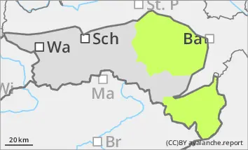
Above 1200 metres there is a considerable avalanche risk (level 3). The stormy winds have created prone-to-triggering snowdrift accumulations in almost all aspects, which can be triggered by individual winter sports enthusiasts in some places as medium-sized, occasionally also as large slab avalanches. The avalanche prone locations are mainly in gullies, bowls and behind terrain edges. Take particular care in the transition from a little to a lot of snow. A few centimetres of new fallen snow and fresh pillows of wind drifted snow can cover the avalanche prone locations and make them difficult to see. Defensive behaviour is recommended for winter sports in open terrain.
Snowpack
From Wednesday evening to Saturday morning, 30 to 70 cm of new fallen snow fell under the influence of strong winds, resulting in large differences in snow depth. Weak layers can be found within the drift snow packs and in the transition to the mostly hardness of the old snowpack. In deep layers in northern aspects, there are still faceted crystals or floating snow in the old snowpack, but these are already interspersed with melt-freeze crusts and can hardly be disturbed. There is a little less snow at low altitudes, especially on sunny slopes. In the lower layers, the snow is moist due to the warm ground and can start to glide on very steep grass mats.
Tendency
The risk of avalanches remains considerable at higher altitudes.
With a northerly high-altitude current, dense clouds will accumulate along the northern side of the Alps for almost the entire Holy Week, with frequent snowfall. Most new fallen snow is expected in the Ybbstal Alps. The north to north-westerly wind will also remain brisk to stormy, leading to the formation of new snow packs.
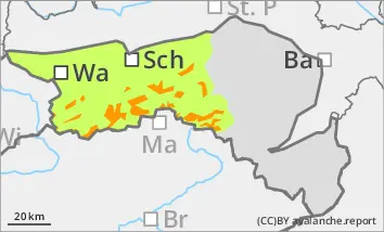
Danger level
Partly prone to wind drifted snow at medium altitudes.
A few centimetres of new fallen snow will be added locally on Sunday, but this will mostly be blown away by the wind. Pillows of wind drifted snow are prone to triggering at medium altitudes.
Snowpack
From Wednesday evening to Saturday morning, 10 to 40 cm of new fallen snow fell on warm, porous ground in the Gutenstein Alps. On the Hochwechsel and in the Bucklige Welt, the amount of fresh snow was significantly lower at 5 to 20 cm. The strong winds caused drift snow packs to form at higher elevations, which were partially covered by a few centimetres of new fallen snow on Sunday.
Tendency
The avalanche risk is not expected to increase.
With a northerly high-altitude current, dense clouds will accumulate along the northern side of the Alps for almost the entire Holy Week, but the amount of new snow will be mostly low. The north to north-westerly winds will also remain brisk to stormy.