Beware of prone to triggering wind slabs! Gliding sluffs are possible at low altitude.
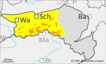
The avalanche risk is considerable above 1200 metres (level 3!). New fallen snow and stormy winds have created fresh snowdrift accumulations in almost all aspects, which can be triggered by individual winter sports enthusiasts as medium-sized, occasionally also as large slab avalanches. The avalanche prone locations are mainly in gullies, bowls and behind terrain edges. Take particular care in the transition from a little to a lot of snow. Spontaneous slab avalanches as well as loose snow avalanches are possible from very steep slopes. Gliding sluffs are possible at low altitude.
Snowpack
30 to 70 cm of new fallen snow has fallen under the influence of strong winds. Weak layers are located within the drift snow packs or in the transition to the old snowpack. In deep layers in northern aspects, there are still faceted crystals or floating snow in the old snowpack, but these may already be interspersed with melt-freeze crusts. There is a little less snow at low altitudes, especially on sunny slopes. In the lower layers, the snow is moist due to the warm ground and may start to glide snow in places as the day warms up.
Tendency
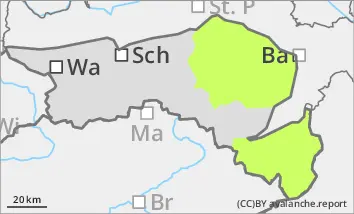
From Sunday, the weather will once again be prone to disruption, it will be mostly cloudy and it will snow lightly from time to time. New drift snow packs form with the stormy wind. The avalanche risk remains the same.
Danger level
1200m
Avalanche Problem
Wind slab
1200m
Slab avalanches can be triggered very easily in gullies and sometimes occur spontaneously!
The avalanche danger above 1200 metres is assessed as considerable (level 3). The new fallen snow and the extensive snowdrift accumulations are prone to triggering, especially above the tree line. The main problem is wind slab. The avalanche prone locations are adjacent to ridgelines and far from ridgelines. They are mainly located in gullies, bowls and behind terrain edges. The layer of drifting snow can be triggered by individual winter sports enthusiasts as a medium-sized avalanche. Spontaneous slab avalanches as well as loose snow avalanches are possible from very steep gullies. Defensive behaviour is recommended when ski touring.
Snowpack
30 to 50 cm of new fallen snow has fallen under the influence of strong winds. Weak layers can be found within the drift snow packs or in the transition to the old snowpack. The snow was transported into gullies and bowls by the stormy north to north-westerly winds. Fresh snowdrift accumulations are deposited above the tree line on a partly still weak old snowpack. The snowdrift accumulations, some of which are thick, should not be underestimated! Weak layers are located in the bound layer or in the transition to the old snowpack.
Tendency
From Sunday, the weather will once again be prone to disruption, it will be mostly cloudy and it will snow lightly from time to time. New drift snow packs form with the stormy wind. There is little change to the avalanche risk. The wind slab problem remains.
Danger level
Occasional gliding sluffs cannot be ruled out.
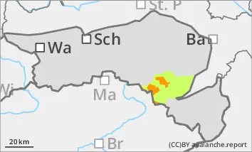
A few centimetres of new fallen snow are added overnight, but these are usually blown away by the wind. Due to the warm ground, the snow can occasionally start to glide on steep slopes or in steep gullies. Pillows of wind drifted snow are prone to triggering at medium altitudes.
Snowpack
In the Gutenstein Alps, 10 to 40 cm of new fallen snow fell on apery, warm ground. On the Hochwechsel and in the Bucklige Welt, the amount of fresh snow was significantly less (around 5 to 20 cm). The strong wind caused drift snow packs to form at higher altitudes.
Tendency
The avalanche risk is not expected to increase.
On Sunday, it will be mostly cloudy and it will snow lightly from time to time. However, the amount of new snow is low. The wind will continue to be stormy in places.