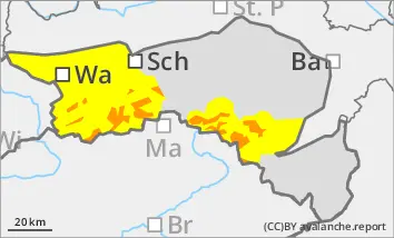
New fallen snow and stormy winds lead to considerable wind slab problems!
The avalanche risk is considerable above 1400 m (level 3!). New fallen snow and stormy winds create fresh snowdrift accumulations in all aspects, which can be triggered by individual winter sports enthusiasts as medium-sized, occasionally also as large slab avalanches. The avalanche prone locations are mainly in gullies, bowls and behind terrain edges. Take particular care in the transition from a little to a lot of snow. Spontaneous slab avalanches as well as loose snow avalanches are possible from very steep slopes. Wet snow slides are possible at low altitude.
Snowpack
20 to 40 cm of new fallen snow has fallen under the influence of strong winds. In addition, there is another 20 to 30 cm of new fallen snow in accumulation areas, which is transported by north to north-easterly winds. Weak layers are located within the drift snow packs or in the transition to the old snowpack. In deep layers in northern, partly also in western and eastern aspects, there are still faceted crystals or floating snow in the old snowpack, but these may already be interspersed with melt-freeze crusts. At low altitudes, the new fallen snow is moist and may start to slide in places.
Tendency
The avalanche danger remains the same on Saturday.
The snowfall will subside in the night to Saturday and the wind will weaken. Due to the rise in temperatures, spontaneous wet snow slides are possible at low altitudes.
Danger level
Avalanche Problem
Wind slab
New snow
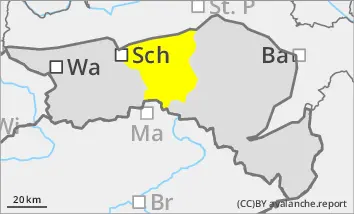
Fresh wind slab is the main problem! Spontaneous slides are possible!
New fallen snow and wind lead to prone to triggering snowdrift accumulations; caution is advised, especially behind terrain edges and in gullies and bowls. Slab avalanches can occasionally reach medium size. At altitudes below 800 metres, the snow is wetter and wet snow slides are also possible from steep slopes and embankments.
Snowpack
20 to 40 cm of new fallen snow fell on mostly apery ground. Wind drifts occurred in exposed areas. Another 20 to 30 cm of new fallen snow will fall from Thursday evening to Friday evening. At low altitudes, the snowfall may also change to rain.
Tendency
The avalanche danger remains the same on Saturday.
The snowfall will subside in the night to Saturday and the wind will weaken. Spontaneous wet snow slides are quite possible due to the rise in temperatures.
Danger level
treeline
Avalanche Problem
Wind slab
Treeline
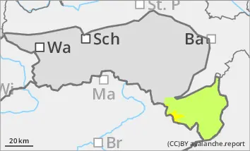
Beware of fresh wind slab!
The avalanche risk is moderate above the tree line. Fresh snowdrift accumulations can be triggered as small to medium-sized avalanches by individual winter sports enthusiasts in all aspects. The avalanche prone locations are mainly in gullies, bowls and behind terrain edges.
Small loose snow slides cannot be ruled out below the tree line.
Snowpack
Around 10 cm of new fallen snow has already fallen on mostly bare ground. By Friday evening, 20 to 30 cm of new fallen snow will be added under strong to stormy winds. Fresh snowdrift accumulations are deposited above the tree line on a stable old snowpack or existing snowdrift packs. Weak layers are located between the drift snow packs or at the transition to the persistent weak layer. At low altitudes, the new fallen snow is partially moist.
Tendency
The avalanche danger remains the same on Saturday.
The snowfall will subside in the night to Saturday and the wind will weaken. Spontaneous wet snow slides are possible due to the rise in temperatures.
Danger level
Avalanche Problem
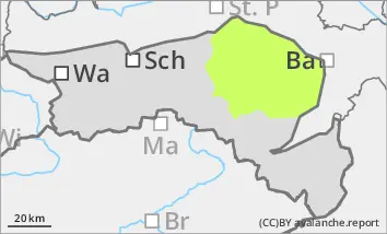
New snow
Spontaneous loose snow slides are possible.
A few centimetres of new fallen snow will be added. As the snow is mostly wet, small loose snow slides may occur occasionally on grass mats or in sparse beech forests.
Snowpack
10 to 20 cm of new fallen snow has fallen above 800 metres on mostly bare ground. There will be another 10 to 20 cm of new fallen snow.
Tendency
The avalanche risk is not expected to increase.
With the rise in temperatures, spontaneous wet snow slides on Saturday cannot be ruled out.