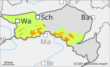
New fallen snow and stormy winds lead to a significant increase in avalanche danger!
The avalanche risk is considerable above the tree line (level 3!). New fallen snow and stormy winds create fresh snowdrift accumulations in all aspects, which can be triggered by individual winter sports enthusiasts as small to medium-sized slab avalanches. The avalanche prone locations are mainly in gullies, bowls and behind terrain edges.
Very occasionally, avalanches can also tear through layers close to the ground. Be especially careful on very steep western, northern and eastern slopes above the tree line. Transitions from a little to a lot of snow are particularly unfavourable.
Snowpack
20 to 40 cm of snow is being transported by strong to stormy north to north-westerly winds. Fresh snowdrift accumulations are deposited above the tree line on a mostly compact old snow surface. Weak layers are located within the drift snow packs or in the transition to the old snowpack. In deep layers in northern, and in some cases also in western and eastern aspects, there are still faceted crystals or floating snow in the old snowpack, but these may already be interspersed with melt-freeze crusts.
Tendency
The avalanche risk will increase on Friday.
An area of low pressure will bring another 20 to 50 cm of new fallen snow, especially in the eastern mountains. Stormy winds will continue to blow.
Danger level
treeline
Avalanche Problem
Wind slab
Treeline
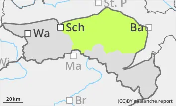
New fallen snow and stormy winds lead to an increase in avalanche danger!
The avalanche risk is moderate above the tree line. Fresh snowdrift accumulations can be triggered as small to medium-sized avalanches by individual winter sports enthusiasts in all aspects. The avalanche prone locations are mainly in gullies, bowls and behind terrain edges.
Small loose snow slides cannot be ruled out below the tree line.
Snowpack
10 to 20 cm of new fallen snow will be transported by strong to stormy north-westerly winds during the day. Fresh snowdrift accumulations are often deposited on a sufficiently stable old snowpack above the tree line. Weak layers are in the bound layer or transition to the persistent weak layer.
Below the tree line, new and wind slab snow is deposited on mostly apery ground.
Tendency
The avalanche risk will increase on Friday.
An area of low pressure will bring another 20 to 50 cm of new fallen snow, especially in the eastern mountains. Stormy winds will continue to blow.
Danger level
Avalanche Problem
New snow
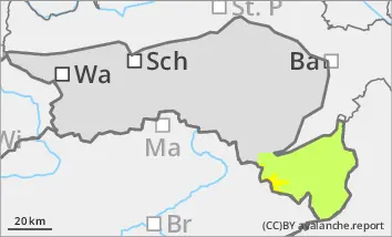
New fallen snow on warm ground can lead to loose snow slides!
At altitudes above 800 metres above sea level, the precipitation falls as snow. However, the new fallen snow can start to slide due to the warm ground. However, the loose snow slides remain small. At low altitudes, rain is mixed in, but due to the smaller amount of new snow, wet snow slides are only possible in isolated cases below 800 metres.
Snowpack
Between 10 and 30 cm of new fallen snow on mostly barren ground. Rain is also mixed in below 800 metres.
Tendency
The avalanche risk will increase on Friday.
An area of low pressure will bring another 20 to 50 cm of new fallen snow, especially in the eastern mountains. Stormy winds will continue to blow.