Watch out for persistent weak layer problems at high altitudes! Slight daytime changes.
The avalanche danger is rated as moderate above 1800 metres. Wet loose snow avalanches from slopes that have not yet been discharged are still possible.
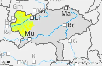
There is still a persistent weak layer problem in the northern sector: in very steep gullies and bowls on the shady slopes, triggering of dry slab avalanches is possible with large additional loads.
Snowpack
During the night, the snowpack regains firmness. However, it loses firmness again due to the sunlight. Up to the high altitudes, the snowpack became wet, moist or hard, depending on the aspect. On the northern slopes of the high altitudes, the kinetic metamorphism (persistent weak layer problem) continues to weaken the snowpack.
Tendency
High pressure weather will continue on Sunday. The wind is coming from the south. No significant change in the avalanche danger is expected.
Danger level
1800m
Avalanche Problem
Persistent weak layer
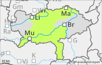
1800m
Persistent weak layer problem in the northern sector!
The avalanche risk is low. Wet loose snow avalanches can occasionally release on their own in extremely steep terrain. However, these will only be slides. In the Gurk and Seetal Alps, the triggering of a snow avalanche in the northern sector on extremely steep slopes cannot be ruled out.
Snowpack
The snowpack will gain some firmness during the night. In the northern sector, there is still a persistent weak layer problem in the Niedere Tauern, in the Hochschwab area but also in the Gruk and Seetal Alps above 1800 metres. Floating snow is weakening the snow layering.
Tendency
High pressure weather will continue on Sunday. Wind from the south. Avalanche danger remains the same.