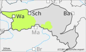
Consider persistent weak layer problems in the northern sector at high altitudes. Isolated loose snow slides.
The avalanche risk is low. At high altitudes above the tree line, there is still a persistent weak layer problem in the northern sector, especially in shady gullies and bowls. Small to medium-sized slab avalanches can occur in a few places under heavy additional load. Avalanche prone locations are mainly in the transition from little to more snow. Occasionally, small wet loose snow slides are still possible, especially during rain showers. However, many areas have already been cleared. Small gliding avalanches can also occur on steep grassy slopes.
Snowpack
Due to the very mild weather phase, the snow surface is quickly soft and moist in the morning. The melt-freeze crust can last longer in shady high altitudes. The old snowpack here is unfavourably structured and weakened in places with crusts and embedded faceted crystals. There is little snow below 1500 metres. On steep grassy slopes and forest embankments with larger snow reserves, the entire snowpack can start gliding snow.
Tendency
On Wednesday, it will be slightly changeable again with rain or snow showers in the afternoon. The snowfall level is between 1500 and 2000 metres. High pressure will prevail from Thursday. The avalanche danger remains low.
Danger level
Avalanche Problem
Wet snow
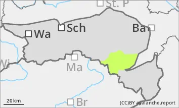
Be aware of isolated loose snow slides and danger of falling in the icy entrance areas of steep gullies.
The avalanche risk is low. Wet loose snow slides are still possible in isolated cases from unloaded gullies and bowls. At higher altitudes, there is an increased risk of falling in the entrance areas to steep gullies due to the icy and hard snow surface. In the transition from little to more snow, small slab avalanches cannot be completely ruled out in the snowdrift accumulations.
Snowpack
Due to the very mild weather phase, the snow surface is quickly soft and moist in sunny locations in the morning. In shady locations, the melt-freeze crust can last longer.
At higher altitudes, the snow surface is usually hard and sometimes icy due to wind and rain. There are still considerable amounts of wind slabs in the gullies and bowls, but these are usually well consolidated. There is little snow below 1500 metres.
Tendency
On Wednesday, it will be slightly changeable again with rain or snow showers in the afternoon. The snowfall level is between 1500 and 2000 metres. High pressure will prevail from Thursday. The avalanche danger remains low.
Danger level
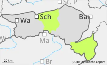
Little snow, the snow is falling.
The avalanche risk is low. Small loose snow slides from slopes that have not yet been unloaded cannot be completely ruled out, but most areas have already been unloaded.
Snowpack
Due to the very mild weather, the snowpack is damp and wet up to high altitudes. Only on northern slopes was a melt-freeze crust able to form in places. The faceted crystals, which have long weakened the foundation of the snowpack in shady gullies, have been largely transformed by rain and melting. There is usually only a little snow up to the summit regions.
Tendency
On Wednesday, it will be slightly changeable again with rain showers in the afternoon. The snowfall level will mostly be above summit level. High pressure will prevail from Thursday. The avalanche risk remains low.