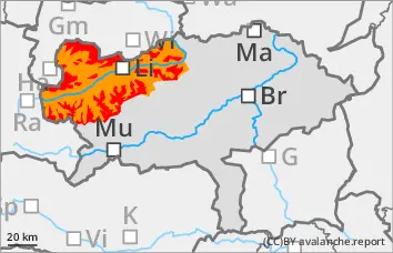
Wet naturally triggered avalanches from all altitudes! Despite the good weather, tours are only possible to a very limited extent!
The avalanche danger is assessed as high (level 4) from 1800 metres. Large amounts of new and wind slab snow (up to 70 cm in the north) have been deposited in the last 24 hours. With the rapid rise in temperatures on Wednesday morning, naturally triggered wet avalanches are to be expected from all aspects. The avalanches can tear through to the ground. Large and occasionally very large avalanches are possible. Spontaneous wet snow avalanches are to be expected at lower elevations and gliding avalanches on steep meadow slopes. Exposed transportation routes are also affected.
Snowpack
There has been 30 to 70 cm of new fallen snow in the last 24 hours. The largest amounts have fallen between the Dachstein, Totem Gebirge and Hochschwab. But there was also some new fallen snow in the Niedere Tauern. The snowfall level was between 1000 m and 1300 m. Stormy winds led to extensive drifts. The snow is damp or wet at low and medium altitudes. At high altitudes, the connection between the new fallen snow and the old snowpack is poor. With the rapid rise in temperature, the snow is becoming wet and heavy right up to the summits.
Tendency
The avalanche danger is decreasing. Naturally triggered avalanches are still possible on Thursday. It remains very mild in the mountains!
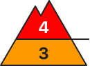
Danger level
Avalanche Problem
Wet snow
Wind slab
1800m
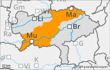
Temperature rise! Wet naturally triggered avalanches!
The avalanche danger is assessed as considerable. Large amounts of new and wind slab snow (up to 40 cm) have been deposited in the last 24 hours. With the rapid rise in temperatures on Wednesday morning, naturally triggered wet avalanches are to be expected from all aspects. The avalanches can tear through to the ground. Spontaneous wet snow avalanches are to be expected at lower elevations and gliding avalanches on steep meadow slopes. Exposed transportation routes are also affected.
Snowpack
There has been 10 to 40 cm of new fallen snow in the last 24 hours. The snowfall level was between 1000 m and 1300 m. Stormy winds led to extensive drifts. The snow is damp or wet at low and medium altitudes. At high altitudes, the connection between the new fallen snow and the old snowpack is poor. With the rapid rise in temperature, the snow is becoming wet and heavy right up to the summits.
Tendency
Under the influence of high pressure, it will remain quite sunny, extremely mild and windless at high altitudes. The risk of avalanches decreases slightly.
Danger level
1300m
Avalanche Problem
Wet snow
1300m
Gliding snow
1300m
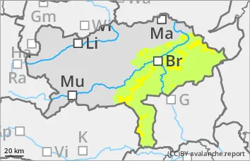
Wet naturally triggered avalanches!
The avalanche danger is rated as moderate above 1300 metres. Wet, naturally triggered avalanches can break loose at any time due to the rapid rise in temperature. Gliding avalanches from grassy slopes are also expected.
Snowpack
Between 10 and 20 cm of new fallen snow has fallen in the last 24 hours. Precipitation centred on the Wechsel region. The snow will quickly become wet on Wednesday up to the summit regions.
Tendency
The avalanche danger is decreasing. It remains mild!