Be careful on very steep slopes in the touring area - persistent weak layer problem!
The avalanche danger is assessed as considerable (level 3) from 1800 metres. It will remain very mild during the night and spontaneous avalanches are still possible in the early morning from avalanche paths that have not yet been discharged. The avalanches can tear through to the ground in the northern sector (documented avalanches on Wednesday impressively demonstrated the situation). In the touring area, releases are possible in very steep gullies and bowls on the shady slopes with little additional load.
Medium to large gliding avalanches can slide from grass mats at any time.
Snowpack
The warming has already allowed the snowpack to settle a little. Due to the mild temperatures and solar radiation, the snowpack is rapidly losing its firmness. On the northern slopes, the kinetic metamorphism (cup crystals in the snow layer close to the ground!) continues to weaken the snowpack.
Tendency
Continuation of high pressure weather with a frost line at an altitude of 2700 metres. Daytime changes in avalanche danger are expected.
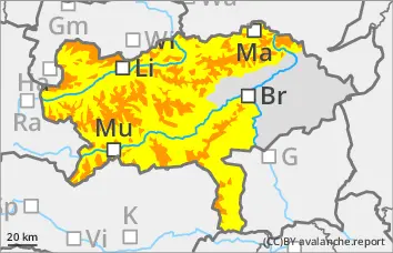
Danger level
1500m
Avalanche Problem
Persistent weak layer
1500m
Wet snow
Pay particular attention to wet snow problems and isolated persistent weak layers
The avalanche risk is moderate at higher altitudes. Wet loose snow avalanches can come loose, especially in extremely steep terrain. Spontaneous avalanche activity increases during the day with incoming radiation and warming.
Drift snow packs are prone to triggering in high, on shady slopes and can occasionally be triggered as a snow slab in steep slope zones.
Snowpack
The new and drifting snow cover has already settled somewhat and lost some of its proneness to triggering. In shady high altitudes, the old snowpack with crusts and embedded angular crystals is unfavourably structured and weakened in places. Depending on the aspect, the snow becomes damp or wet during the day changes up to high altitudes, leading to a decreasing firmness and destabilisation of the snowpack.
Tendency
With calm, high-pressure weather, the avalanche risk will slowly decrease towards the end of the week.
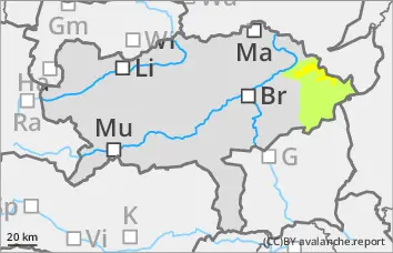
Danger level
Avalanche Problem
Wet snow
Wet snow!
The avalanche risk is rated as low. Occasional small wet slides are possible.
Snowpack
The snowpack is wet or soaked.
Tendency
Continuation of high pressure weather with a frost line at an altitude of 2700 metres.