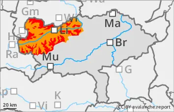
The avalanche danger is assessed as high (level 4) from 1800 metres upwards. During the intense precipitation in combination with storms (transport!), spontaneous discharges are expected at high altitudes. At lower elevations, spontaneous wet snow avalanches and gliding avalanches on steep meadow slopes are to be expected. Exposed transportation routes may be affected.
In the touring area, it is difficult to assess the avalanche situation in the prevailing weather conditions. Slab avalanches can be triggered on many steep slopes with little additional load.
Snowpack
New fallen snow and strong winds from the west to northwest have led to extensive transported snow and in some cases massive snowdrift accumulations in the aspects from northeast to east to south in the past few days. In addition, 30 to 50 cm of new fallen snow is expected in stormy conditions. The connection between the wind slab and the old snowpack will not be sufficient. There are still weak layers in the transition to the persistent weak layer. In the shady areas, the snowpack is weakened by faceted crystals and floating snow.
Tendency
High pressure influence and massive warming at altitude from Wednesday lunchtime. The zero-degree level will rise to 3000 metres by Wednesday evening. The high avalanche risk remains.
Danger level
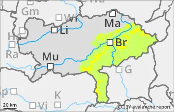
treeline
Avalanche Problem
Wind slab
Treeline
Wet snow
Treeline
Prone to triggering wind slab snow in the higher elevations! Beginning of wet snow problems at lower altitudes.
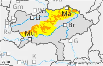
The avalanche danger is assessed as considerable. Drifting snow - persistent stormy north-westerly winds form fresh wind slabs that are prone to triggering. The north, east and south sectors are particularly affected. In some places, medium-sized slab avalanches can be triggered by individual winter sports enthusiasts. However, spontaneous slab avalanches are also to be expected. Spontaneous wet snow avalanches and smaller gliding avalanches can occur at lower and medium altitudes, including on steep forest slopes or embankments.
Snowpack
The connection between the drift snow packs and the old snowpack is sometimes insufficient. At shady high altitudes, the old snowpack is unfavourably structured in places with crusts and embedded angular crystals. With increasing moisture penetration, the snowpack loses stability at lower altitudes and can also start to glide snow on steep grass and forest slopes.
Tendency
The weather will deteriorate again on Tuesday night, with heavy rain and snowfall starting again after midnight at the latest. Above around 1000 metres, a good 10 to 20 cm of new fallen snow is possible by midday on Tuesday. It will remain stormy! The risk of avalanches is increasing!
Danger level
Avalanche Problem
Persistent weak layer
Wind slab
Moderate avalanche danger. Fresh wind slab!
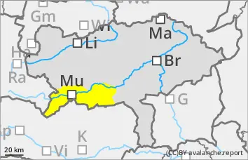
The avalanche danger is rated as moderate. Particular caution is required behind terrain edges and in entrances to gullies and bowls. Medium-sized and occasionally large slab avalanches can be triggered by individuals in some places. Spontaneous wet snow avalanches are to be expected at lower altitudes and gliding avalanches on steep meadow slopes.
Snowpack
Fresh wind slab snow overlays older wind slab snow! In the aspects from north-east to east to south, there are still older snowdrift accumulations lying on a weak layer of surface hoar or faceted crystals. The snow base, fundament is weakened by faceted crystals and floating snow. At lower elevations, the snow becomes moist and loses firmness. On steep meadow slopes, the snow can begin to glide.
Tendency
High pressure influence and massive warming at altitude from Wednesday lunchtime. The zero-degree level will rise to 3000 metres by Wednesday evening. Wet snow avalanches will be an issue on Wednesday!
Danger level
1500m
Avalanche Problem
Wind slab
1500m
Persistent weak layer
1500m
Fresh wind slab!
The avalanche danger is assessed as moderate above 1500 metres. The avalanche prone locations are in the north and east sectors. Fresh wind slabs can easily be triggered by an alpinist.
Snowpack
Fresh wind slab is deposited on a wet or moist snowpack. The connection between the two layers will not be sufficient.
Tendency
High pressure influence and massive warming at altitude from Wednesday lunchtime. The zero-degree level will rise to 3000 metres by Wednesday evening. Isolated wet snow slides are possible on Wednesday.