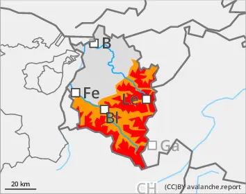
Dangerous avalanche situation persists apart from heavily skied terrain
Large amounts of fresh snow and drifts from last week blanket a weak old snowpack. Avalanches can easily be triggered by one single winter sports enthusiast in all aspects, especially in little-skied terrain. Danger zones increase with ascending altitude, occur widespread in terrain near to and distant from ridgelines. Caution urged in transitions from shallow to deep snow, for example, at entries into gullies and bowls. Remote triggerings are possible. Avalanches can be large-sized and plummet over flattish passages. As a result of renewed rainfall and the snowpack becoming ever wetter, wet slab avalanches can be expected at low and intermediate altitudes. If these fracture to deeper down layers of the snowpack, they can in isolated cases grow to large size. On steep grass-covered slopes, glide-snow avalanches can trigger. Zones with glide cracks should under all circumstances be avoided.
Snowpack
During the night there was 20mm of rainfall registered in the northern regions of highest precipitation. During the daytime, another 10mm can be added to that. Above 2000m, about 15 cm of fresh snow, accompanied by strong-velocity winds. The large amounts of fresh snow from the last few days have been repeatedly transported in varying directions, snowdrift accumulations are poorly bonded with the old snowpack. Weak layers are widely prevalent in the lower part of the snowpack. The extraordinary avalanche activity last week confirms just how prone to triggering the weak layer is. This layer persists apart from heavily skied zones and in starting zones which have not yet discharged. At low and intermediate altitudes the snowpack is thoroughly wet. Even at higher altitudes there are breakable crusts, particularly in areas exposed to the sun.
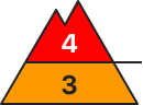
Tendency
Avalanche danger is gradually diminishing, but the situation for winter sports enthusiasts remains extremely treacherous in little-skied terrain
Danger level
2000m
Avalanche Problem
Wet snow
2000m
Wind slab
2000m
Persistent weak layer
1800m
Rainfall leading to wet-snow avalanches
Due to heavy rain impact, increasingly frequent medium-sized wet-snow avalanches can be expected in steep terrain. Where there is lots of snow on the ground, these releases can grow to large size. On steep grass-covered slopes, glide-snow avalanches can occur. Zones with glide cracks on the surface should under all circumstances be avoided. At high altitudes, avalanches can be triggered even by one single winter sports enthusiasts, particular from freshly generated snowdrift accumulations. Danger zones occur in steep ridgeline terrain and behind abrupt changes in the terrain. Particularly on very steep shady slopes above 1800m, avalanches can fracture down to deeper-down layers inside the snowpack and then grow to large size. Whumpf noises and fractures which appear when treading upon the snowpack are alarm signals.
Snowpack
About 20mm of rain was registered during the nocturnal hours. During the daytime another 15mm can be added to that. Above 2000m, about 15cm of fresh snow, accompanied by strong-velocity winds. At high altitudes, fresh and older snowdrift accumulations in all aspects are only moderately to poorly bonded with the generally weak old snowpac. On shady slopes there are weak layers in the lower part of the snowpack.
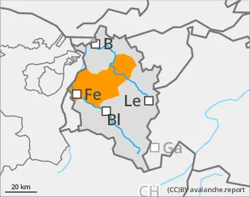
Tendency
Wet-snow activity will decrease when the precipitation ceases. Then a high-pressure front will diminish avalanche danger also at high altitudes.
Danger level
Avalanche Problem
Wet snow
Gliding snow
Rainfall leading to wet loose-snow avalanches
Wet loose-snow avalanches of medium size can be expected in very steep terrain. On steep grass-covered slopes, glide-snow avalanches can release. Zones with glide cracks on the surface should under all circumstances be avoided.
Snowpack
Where there is snow on the ground, it is thoroughly wet.
Tendency
Wet-snow activity will end when the precipitation ceases. Then, when high-pressure weather conditions set it, the ground will become further bare of snow.