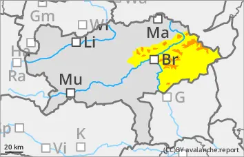
Significant avalanche danger above the tree line! Avalanche prone locations difficult to recognise!
The avalanche risk is considerable above the tree line and moderate below it. During the night to Friday, fresh, unstable wind slabs will form in the north, west and south-east sectors, some of which will be covered by soft new fallen snow. The avalanche prone locations are therefore difficult to recognise and can also occur in unusual aspects. They are generally located on slopes that have been blown in, in terrain adjacent to ridgelines and at the entrances to gullies and bowls. Medium-sized slab avalanches can be triggered by a single person. Spontaneous slab avalanches are also possible.
Snowpack
Up to 50 cm of new fallen snow is expected from Thursday evening to Friday lunchtime, some of which will be transported by wind from various directions. The fresh wind slab may contain weak layers. The snow will often fall on bare ground. Where there is a snow base, fundament, it is crusted can form and hard. On steep meadow slopes, the snow can begin to glide.
Tendency
On Saturday and Sunday, a warm front will bring thick clouds and plenty of new fallen snow from the main ridge northwards. However, the snowfall level will gradually rise to an altitude of 1000 to 1400 metres.
Increasing wet and sliding snow activity is expected from Sunday.
Danger level
treeline
Avalanche Problem
Wind slab
Treeline
Persistent weak layer
Treeline
Wind slab
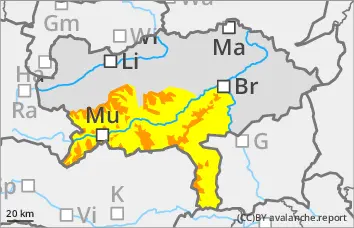
Significant avalanche danger above the tree line! Avalanche prone locations difficult to recognise!
The avalanche risk is considerable above the tree line and moderate below it. During the night to Friday, fresh, unstable wind slabs will form in the north, west and south-east sectors, some of which will be covered by soft new fallen snow. The avalanche prone locations are therefore difficult to recognise and can also occur in unusual aspects. They are generally located on slopes that have been blown in, in terrain adjacent to ridgelines and at the entrances to gullies and bowls. Medium-sized slab avalanches can be triggered by a single person. Spontaneous slab avalanches are also possible.
Snowpack
From Thursday evening to Friday lunchtime, up to 50 cm of new fallen snow is expected in the peripheral mountains and up to 20 cm in the more westerly mountain groups, some of which will be transported by winds from various directions. The fresh wind slab may contain weak layers. The snow base, fundament is unstable due to weak layers of snow-covered surface hoar and floating snow. The snow can begin to glide snow on steep meadow slopes.
Tendency
On Saturday and Sunday, a warm front will bring thick clouds and plenty of new fallen snow from the main ridge northwards. However, the snowfall level will gradually rise to an altitude of 1000 to 1400 metres.
Increasing wet and sliding snow activity is expected from Sunday.
Danger level
treeline
Avalanche Problem
Wind slab
Treeline
Persistent weak layer
Treeline
Wind slab
Treeline
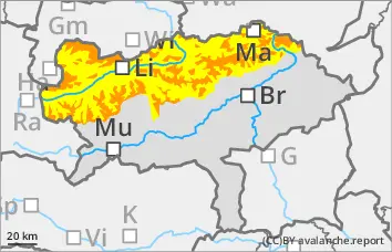
Significant avalanche danger above the tree line! Avalanche prone locations difficult to recognise!
The avalanche risk is considerable above the tree line and moderate below it. During the night to Friday, fresh, unstable wind slabs will form in the north, west and south-east sectors, some of which will be covered by soft new fallen snow. The avalanche prone locations are therefore difficult to recognise and can also occur in unusual aspects. They are generally located on slopes that have been blown in, in terrain adjacent to ridgelines and at the entrances to gullies and bowls. Medium-sized slab avalanches can be triggered by a single person. Spontaneous slab avalanches are also possible.
Snowpack
Up to 20 cm of new fallen snow is expected from Thursday evening to Friday lunchtime, some of which will be transported by wind from various directions. The fresh wind slab may contain weak layers. The snow base, fundament is unstable due to weak layers of snow-covered surface hoar and floating snow. The snow can begin to glide snow on steep meadow slopes.
Tendency
On Saturday and Sunday, a warm front will bring thick clouds and plenty of new fallen snow from the main ridge northwards. However, the snowfall level will gradually rise to between 1000 and 1400 metres above sea level.
Larger, naturally triggered avalanches are also increasingly likely in the northern Alps.