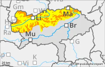
Significant avalanche danger above the tree line! Avalanche prone locations difficult to recognise!
The avalanche risk is considerable above the tree line and moderate below. Avalanche prone locations are snow-covered slopes of all aspects, in particular the east and south sectors. Particular caution is required behind terrain edges and in entrances to gullies and bowls. Medium-sized slab avalanches can be triggered by individuals in many places. Spontaneous loose snow avalanches can also occur at lower altitudes.
Snowpack
Up to 20 cm of new fallen snow was transported by winds from various directions. Fresh drifts will form in the east and south sectors over the course of Saturday. Weak layers are possible both in the fresh wind slabs and in the transition to persistent weak layers. The snow base, fundament is weakened by faceted crystals and floating snow.
Tendency
On Saturday and Sunday, a warm front will bring thick clouds and plenty of new fallen snow from the main ridge northwards. However, the snowfall level will gradually rise to between 1000 and 1400 metres above sea level.
Larger, naturally triggered avalanches are also increasingly likely in the northern Alps.
Danger level
treeline
Avalanche Problem
Wind slab
Treeline
Persistent weak layer
Treeline
Wind slab
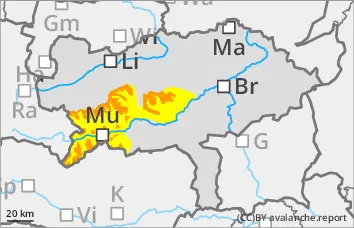
Significant avalanche danger above the tree line! Avalanche prone locations difficult to recognise!
The avalanche risk is considerable above the tree line and moderate below. Avalanche prone locations are snow-covered slopes of all aspects, in particular east and south. Particular caution is required behind terrain edges and in entrances to gullies and bowls. Medium-sized slab avalanches can be triggered by individuals in many places.
Snowpack
Up to 30 cm of new fallen snow was transported by winds from various directions. Fresh drifts will form in the east and south sectors over the course of Saturday. Weak layers are possible both in the fresh wind slabs and in the transition to persistent weak layers. The snow base, fundament is weakened by faceted crystals and floating snow.
Tendency
On Saturday and Sunday, a warm front will bring thick clouds and plenty of new fallen snow from the main ridge northwards. However, the snowfall level will gradually rise to an altitude of 1000 to 1400 metres.
Increasing wet and sliding snow activity is expected from Sunday.
Danger level
treeline
Avalanche Problem
Wind slab
Treeline
Gliding snow
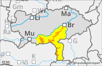
Significant avalanche danger, wind slab problem!
The avalanche risk is considerable above the tree line and moderate below. Avalanche prone locations are snow-covered slopes of all aspects, in particular east and south. Particular caution is required behind terrain edges and in entrances to gullies and bowls. Medium-sized slab avalanches can be triggered by individuals in many places. At lower altitudes, spontaneous gliding avalanches can occur on steep grassy slopes.
Snowpack
Up to 60 cm of new fallen snow was transported by winds from various directions. In the course of Saturday, fresh drifts will form in the east and south sectors. Weak layers are possible both in the fresh wind slabs and in the transition to persistent weak layers. The snow base, fundament is weakened by faceted crystals and floating snow. On steep meadow slopes, the snow can begin to glide.
Tendency
Danger level
treeline
Avalanche Problem
Wind slab
Treeline
Gliding snow
Treeline
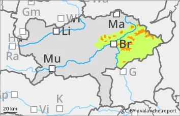
Little new fallen snow.
Significant avalanche danger above the tree line!
The avalanche risk is considerable above the tree line and low below. Avalanche prone locations are snow-covered slopes of all aspects, in particular east and south. Take particular care behind terrain edges and in entrances to gullies and bowls. Medium-sized slab avalanches can be triggered by a single person in many places. At lower elevations, spontaneous gliding avalanches can occasionally occur on steep grassy slopes.
Snowpack
Up to 40 cm of new fallen snow was transported by winds from various directions. In the course of Saturday, fresh drifts will form in the east and south sectors. Weak layers are possible both in the fresh wind slabs and in the transition to persistent weak layers. Where there is a snow base, fundament, it is crusted can form and hard. On steep meadow slopes, the snow can begin to glide.
Tendency
On Saturday and Sunday, a warm front will bring thick clouds and plenty of new fallen snow from the main ridge northwards. However, the snowfall level will gradually rise to an altitude of 1000 to 1400 metres.
Increasing wet and sliding snow activity is expected from Sunday.