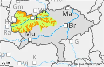
The avalanche risk increases rapidly with altitude and is assessed as considerable above the tree line. The persistent weak layer problem is still present and is currently exacerbated by fresh wind slab. The avalanche prone locations are from north-west to south-east on slopes that have been blown in, in terrain adjacent to ridgelines and at the entrances to gullies and bowls. Medium-sized slab avalanches can be triggered by individuals.
Snowpack
Up to 30 cm of new fallen snow has fallen since Saturday, with a few centimetres more to come on Tuesday. Stormy north-westerly winds led to extensive drifting. Some of the fresh wind slab snow contains weak layers and the snow base, fundament is weakened by snow-covered surface hoar and floating snow.
Tendency
Heavy snowfall is expected during the night from Thursday to Friday. The risk of avalanches is increasing.
EARLIER Danger level
treeline
Avalanche Problem
Wind slab
Treeline
Persistent weak layer
Treeline
LATER Danger level
treeline
Avalanche Problem
Wind slab
Treeline
Persistent weak layer
Treeline
Fresh wind slab, avalanche danger increases in the afternoon!
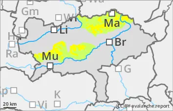
The avalanche risk is moderate above the tree line in the morning and low below. In the afternoon, the avalanche danger increases to considerable! The persistent weak layer problem is still present and is increasingly exacerbated by fresh wind slab from midday. The avalanche prone locations are mainly on north to south-east facing slopes above the tree line. Here, snowdrift accumulations in many places can be triggered by individuals as slab avalanches.
Snowpack
A total of up to 20 cm of new fallen snow has fallen since Saturday. Stormy north-westerly winds and later southerly winds led to drifts. Around 10 cm of new fallen snow will be added on Thursday afternoon. The snow base, fundament is weakened by snow-covered surface hoar and floating snow.
Tendency
Heavy snowfall is expected during the night from Thursday to Friday. The risk of avalanches is increasing.
Danger level
treeline
Avalanche Problem
Persistent weak layer
Treeline
Wind slab
Fresh wind slab, moderate avalanche danger above the tree line!
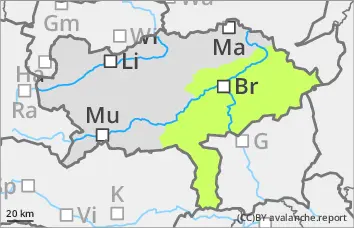
The avalanche risk is moderate above the tree line and low below. The persistent weak layer problem is still present and is currently exacerbated by fresh wind slab. The avalanche prone locations are mainly on north to south-east facing slopes above the tree line. Here, fresh and older snowdrift accumulations can be triggered by individuals as slab avalanches in some places.
Snowpack
A total of up to 20 cm of new fallen snow has fallen since Saturday. Stormy north-westerly winds and later southerly winds led to drifts. The snow base, fundament is weakened by snow-covered surface hoar and floating snow.
Tendency
Heavy snowfall is expected during the night from Thursday to Friday. The risk of avalanches is increasing.
EARLIER Danger level
Avalanche Problem
Wind slab
LATER Danger level
treeline
Avalanche Problem
Wind slab
Treeline
Little new fallen snow.
Increase in avalanche danger due to fresh wind slab!
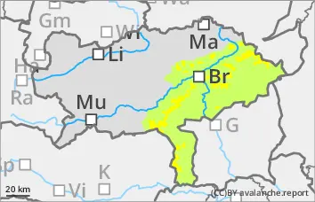
The avalanche risk is still low in the morning and increases to moderate in the afternoon above the tree line. In some places at high altitudes, adjacent to ridgelines and in entrances to gullies and bowls, fresh pillows of wind drifted snow in the north-west to south-east aspect can be triggered as mostly small slab avalanches.
Snowpack
A little new fallen snow and strong winds led to the formation of pillows of wind drifted snow. The wind slab lies on a hardness of old snowpack or on a soft layer. In the higher elevations, angular snow crystals continue to weaken the stability on shady slopes.
Tendency
Heavy snowfall is expected during the night from Thursday to Friday. The risk of avalanches is increasing.