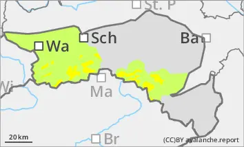
Above the tree line there is moderate avalanche danger (level 2). The soft new fallen snow was transported by strong west to north-westerly winds. Fresh snowdrift accumulations have formed, especially in the north to south-east aspects. Adjacent to ridgelines and in gullies and bowls, these can be triggered by winter sports enthusiasts as slab avalanches in some places. Occasional triggering is also possible in forest aisles. There is still a persistent weak layer problem on shady slopes at high altitudes. Avalanches can occasionally tear through angular weak layers and reach medium size.
Snowpack
In the last few days, 10 to 20 cm of new fallen snow has fallen across the region, with more than 20 cm locally in the Ybbstal Alps. The snow was transported by strong westerly to north-westerly winds. The fresh drift snow packs are lying on decomposed snow or older drift snow layers and are prone to triggering in places. The underlying old snowpack is unfavourably structured in places with crusts and embedded faceted crystals. There are weak layers both at the transitions to the wind slab and within the old snowpack. With the onset of precipitation, some new fallen snow will be added in the afternoon above around 1000 metres, below which rain or sleet may moisten the snowpack.
Tendency
Heavy precipitation will spread from the south-east during the night to Friday. The snowfall level is in the valleys. By Friday morning, 10 to 25 cm of new fallen snow will have fallen. The avalanche risk increases slightly on Friday.
Danger level
Avalanche Problem
Wind slab
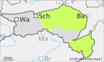
Low avalanche danger, but still isolated avalanche prone locations in gullies and bowls.
With strong westerly to north-westerly winds, drift snow packs have formed in gullies and bowls as well as behind terrain edges. These can occasionally be triggered as small slab avalanches. In shady gullies and bowls, it is possible to tear through weak layers of old snow, but avalanches will remain small. Localised wet snow slides cannot be ruled out below around 1000 m due to rain in the afternoon.
Snowpack
The new fallen snow of the last few days has been transported by the wind in exposed areas. In the aspects from north to east to south, drift snow packs have formed in gullies and bowls. Below 1000 metres there is usually only a thin snowpack. With the onset of precipitation, some new fallen snow will be added in the afternoon above around 1000 metres, below which rain or sleet may moisten the snowpack.
Tendency
Heavy precipitation will spread from the south-east during the night to Friday. The snowfall level will be in the valleys. By Friday morning, 10 to 20 cm of new fallen snow will be widespread, with up to 30 cm possible locally.
The risk of avalanches increases on Friday.