Pay attention to fresh, prone to triggering wind slab.
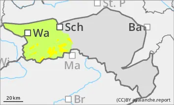
Above the tree line there is a moderate avalanche risk (level 2). The soft new fallen snow was transported by strong westerly to north-westerly winds and fresh snowdrift accumulations formed, especially in the north, east and south aspects. Adjacent to ridgelines and in gullies and bowls, drift snow packs can be triggered as slab avalanches in some places by individual winter sports enthusiasts. Occasional avalanches are also possible in forest aisles. There is still a persistent weak layer problem on shady slopes at high altitudes. Avalanches can occasionally tear through angular weak layers and reach medium size.
Snowpack
Above an altitude of around 1000 metres, another 10 to 20 cm of new fallen snow has been brought in by strong north-westerly winds. The fresh drift snow packs have deposited on decomposed snow or older drift snow layers and are often prone to triggering. Underneath, the old snowpack is unfavourably structured in places with crusts and faceted crystals. There are weak layers both at the transitions to the wind slab and within the old snowpack.
Tendency
A Mediterranean low will approach from the south on Thursday. During the afternoon, it will start to snow above around 1000 metres. During the night to Friday, it may snow heavily down to the valleys. Around 10 cm of new fallen snow will accumulate.
The avalanche risk remains moderate in the Ybbstal Alps above the tree line.
Danger level
Avalanche Problem
Wind slab
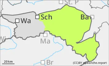
Low avalanche danger, but still isolated avalanche prone locations in gullies and bowls.
With the strong north-westerly wind, thin pillows of wind drifted snow have formed, which can be triggered as small slab avalanches in a few places with little additional load. In shady gullies and bowls, tearing through weak layers of old snow is possible, but avalanches usually remain small. The risk of entrainment and falling outweighs the risk of burial. Hardness or icy surfaces were covered by little new fallen snow and are sometimes difficult to recognise.
Snowpack
At high altitudes, there is a considerable amount of older and mostly well-settled wind slab in some places in gullies and bowls. However, the snow thickness is rapidly decreasing distant from ridgelines. The new fallen snow of the last few days has also been transported. In the north, east and south aspects, thin pillows of wind drifted snow have formed in gullies and bowls, while windward areas are often icy and snow-poor. Below 1000 metres, a thin snowpack has formed on mostly bare ground.
Tendency
A Mediterranean low will approach from the south on Thursday. During the afternoon, it will start to snow above around 1000 metres. During the night to Friday, it may snow heavily down to the valleys. More than 10 cm of new fallen snow is expected.
The avalanche risk will remain low on Thursday.