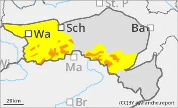
The avalanche risk increases rapidly with altitude and is assessed as considerable (level 3) above the tree line. The drift snow packs are first covered by new fallen snow, then new drift snow packs form. Adjacent to ridgelines and in gullies and bowls, small to medium-sized slab avalanches can be triggered by winter sports enthusiasts in some places. Triggering is also possible in forest aisles. Avalanche prone locations are difficult to recognise due to the new fallen snow. There is still a persistent weak layer problem on shady slopes at high altitudes. Avalanches can occasionally tear through angular weak layers and reach medium size.
Snowpack
During the night to Friday, 10 to 30 cm of new fallen snow will fall, which will be transported by strong north-easterly winds in places. The drift snow packs are deposited on the snowdrift accumulations of the last few days or on the old snowpack. This is unfavourably structured in places with crusts and embedded faceted crystals. There are weak layers both at the transitions to the wind slab and within the old snowpack.
Tendency
There will be no precipitation during the night until Saturday. On Saturday, the current will turn to the west and stormy winds will arise. A warm front is expected to bring precipitation again on Sunday night. However, the snowfall level will rise significantly. The avalanche risk remains considerable above the tree line.
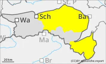
Danger level
Avalanche Problem
New snow
New fallen snow leads to an increase in avalanche danger!
The avalanche danger is assessed as moderate (level 2). During the night to Friday, fresh, unstable wind slabs will form in the north, west and south-east sectors, some of which will be covered by soft new fallen snow. The avalanche prone locations are therefore difficult to recognise and can also occur in unusual aspects. They are generally located on slopes that have been blown in, in terrain adjacent to ridgelines and at the entrances to gullies and bowls. Small, and occasionally medium-sized, slab avalanches can be triggered by a single person. Spontaneous slab avalanches are also possible.
Snowpack
Between Thursday evening and Friday lunchtime, 20 to 30 cm of new fallen snow is expected, with up to 50 cm possible in the Wechsel area. Some of the new fallen snow will be transported by wind from various directions. The fresh wind slabs may contain weak layers. At low altitudes, the snow will often fall on loose ground, at higher altitudes on older snowdrift accumulations or a crusted can form old snowpack. On steep meadow slopes, the snow can begin to glide snow.
Tendency
There will be no precipitation during the night until Saturday. On Saturday, the current will turn to the west and strong to stormy winds will develop. A warm front is expected to bring precipitation again on Sunday night. However, the snowfall level will rise significantly. The avalanche danger remains moderate (level 2).