Pay attention to fresh, prone to triggering wind slab.
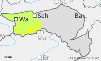
Above the tree line there is a moderate avalanche risk (level 2). Soft new fallen snow is transported by strong westerly to north-westerly winds and fresh snowdrift accumulations form, especially in the north, east and south aspects, adjacent to ridgelines and in steep gullies and bowls. These can be triggered by individual winter sports enthusiasts as slab avalanches, especially in the transition from a little to a lot of snow. There is still a persistent weak layer problem on shady slopes at high altitudes. Avalanches can occasionally tear through angular weak layers and reach medium size.
Snowpack
Above around 1000 m, another 10 to 25 cm of new fallen snow will fall, which will be transported by strong north-westerly winds. Fresh drift snow packs are lying on decomposed snow or older drift snow layers and are prone to triggering in places. Underneath, the old snowpack is unfavourably structured in places with crusts and faceted crystals. There are weak layers both at the transitions to the wind slab and within the old snowpack.
Tendency
The avalanche risk remains moderate in the Ybbstal Alps above the tree line.
It will continue to snow in places during the night into Wednesday. The precipitation will gradually subside on Wednesday morning. There will be no precipitation in the afternoon.
Danger level
1500m
Avalanche Problem
Wind slab
1500m
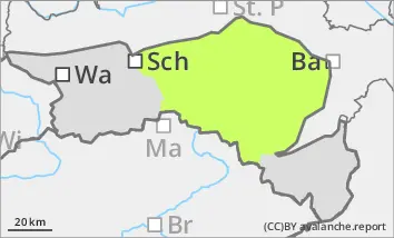
Low avalanche danger, watch out for fresh pillows of wind drifted snow at high altitudes.
At high altitudes, there are sometimes considerable snowdrift accumulations in steep gullies and bowls. These are prone to triggering, especially in the transition from a little to a lot of snow. Tearing through weak layers of old snow is possible, but avalanches remain small. The risk of tearing and falling outweighs the risk of burial. Hardness or icy surfaces can be covered by little new fallen snow and be difficult to recognise.
Snowpack
At high altitudes, there is a considerable amount of wind slab snow in places in gullies and bowls. The new fallen snow of the last few days has also been transported. The snow thickness is rapidly decreasing distant from ridgelines. Above 1500 m, thin pillows of wind drifted snow can be found in northern and eastern exposures, while windward areas are often icy and snow-poor. Below 1500 m, a snowpack of up to 10 cm has formed on mostly bare ground.
Tendency
The avalanche danger remains low.
It will still snow intermittently during the night to Wednesday. There will be no precipitation during the day.