Freshly generated snowdrifts atop unfavorable old snowpack
Medium-sized slab avalanches can easily be triggered by one single person in the drifts and in the old snow. Also remote triggerings cannot be ruled out. Avalanche danger increases with ascending altitude starting at the treeline, above 1800m danger is considerable. Danger zones occur in wind-loaded steep terrain, behind drops in the landscape and in gullies and bowls. Avalanche prone locations are not visible to the naked eye and make a defensive route selection imperative. Marked weak layers in the old snow occur particularly on steep, little skied-on slopes and are easy to trigger. Also superficially triggered avalanches can fracture down to deeper layers of the snowpack and then grow to larger size. Whumpf noises and fractures on the surface are alarm signals.
Snowpack
Tonight, 5-10cm of snowfall is anticipated, in the Rätikon up to 20cm of fresh snow. The often trigger-sensitive snowdrift accumulations from recent days will be blanketed, making them difficult to see. As a result of northerly winds, fresh, trigger-sensitive snowdrift accumulations will be generated at high altitudes. Particularly on steep shady high-altitude slopes, the fresh snow and drifts will cover a weak old snowpack. Over the last few days, graupel, in wind-protected zones also surface hoar or trigger-sensitive, thin melt-freeze crusts have been blanketed by fresh snow. Snow profiles, successful artificial triggerings with explosives and observations in outlying terrain confirm just how weak the snowpack structuring is.
Tendency
As a result of heavy snowfall and storm-strength winds, avalanche danger will increase significantly on Monday
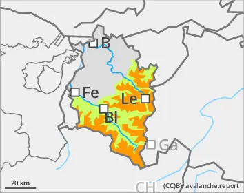
Danger level
1800m
Avalanche Problem
Persistent weak layer
1800m
Wind slab
Treeline
Beware fresh snowdrift accumulations, they can easily be triggered
Medium-sized slab avalanches can easily be triggered by one single person in the drifts and in the old snow. Danger zones occur in wind-loaded steep terrain, behind drops in the landscape and in gullies and bowls. Avalanche prone locations are not visible to the naked eye and make a defensive route selection imperative. Superficially triggered avalanches can fracture down to deeper layers of the snowpack and then grow to larger size. Danger zones increase in frequency and size with ascending altitude.
Snowpack
Tonight, 5-10cm of snowfall is anticipated, in the Rätikon up to 20cm of fresh snow. The often trigger-sensitive snowdrift accumulations from recent days will be blanketed, making them difficult to see. As a result of northerly winds, fresh, trigger-sensitive snowdrift accumulations will be generated at high altitudes. Particularly on steep shady high-altitude slopes, the fresh snow and drifts will cover a weak old snowpack. Over the last few days, graupel, in wind-protected zones also surface hoar or trigger-sensitive, thin melt-freeze crusts have been blanketed by fresh snow. Snow profiles, successful artificial triggerings with explosives and observations in outlying terrain confirm just how weak the snowpack structuring is.
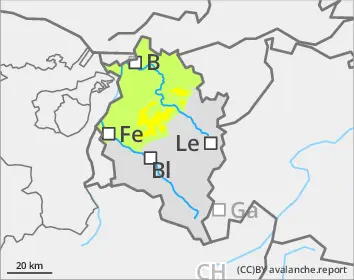
Tendency
As a result of heavy snowfall and storm-strength winds, avalanche danger will increase significantly on Monday.