Pay attention to fresh, prone to triggering wind slab.
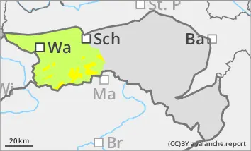
Above the tree line there is moderate avalanche danger (level 2). Below the tree line, the danger is usually low (level 1). With the new fallen snow and increasingly strong winds, fresh snowdrift accumulations are forming. These are mainly in the north, east and south aspects and can be triggered by individual winter sports enthusiasts as small slab avalanches. There is still a persistent weak layer problem on shady slopes at high altitudes. Avalanches can occasionally tear through the persistent weak layer, but usually remain small. The risk of falling and injury generally outweighs the risk of burial, be careful in the area of terrain traps.
Snowpack
Around 10 cm, sometimes up to 20 cm in accumulations, of new fallen snow falls under the influence of strong winds. This causes drift snow packs to form, which are deposited on decomposed snow or older drift snow packs. Underneath is a partly unfavourable old snowpack with several crusts and embedded faceted crystals. There are weak layers between the fresh drift snow and decomposed snow as well as within the old snowpack.
Tendency
The avalanche danger remains the same.
In the night to Monday, strong to stormy westerly winds will develop with the passage of a warm front. On Monday, it will snow intermittently in the morning and the clouds will soften at times in the afternoon. In the evening and on Tuesday night, a north-westerly weather pattern sets in, leading to more snowfall.
Danger level
treeline
Avalanche Problem
Wind slab
Treeline
Persistent weak layer
Treeline
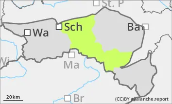
Low avalanche danger, watch out for fresh pillows of wind drifted snow at high altitudes.
The avalanche risk is low (level 1). Fresh pillows of wind drifted snow can be found occasionally in aspects from north to south-east and can be triggered as small slab avalanches by individual winter sports enthusiasts adjacent to ridgelines. There is a persistent weak layer problem on shady slopes at high altitudes - avalanches can occasionally tear through the old snow, but remain small. The risk of entrainment, falling and injury outweighs the risk of burial. Hardness or icy surfaces can be covered by little snow and be difficult to recognise.
Snowpack
Around 5 cm of new fallen snow will fall in the night to Sunday. In the Türnitz Alps it could be up to 10 cm. With the strong north-westerly wind, pillows of wind drifted snow will form, which will be deposited on a crusted can form surface of old snow at higher altitudes. The foundation of the old snowpack is still weakened by deep rime and faceted crystals at shady high altitudes. There are usually several melt-freeze crusts on top. In general, there is little snow, in southern aspects and below around 1300 metres, the slopes were mostly bare before the snowfall.
Tendency
The avalanche danger remains the same.
In the night to Monday, strong to stormy westerly winds will develop with the passage of a warm front. Monday will be mostly free of precipitation and the clouds will soften at times. In the evening and on Tuesday night, a north-westerly weather pattern sets in, making a few centimetres of new fallen snow possible again.