Weak layers in persistent weak layers remain prone to triggering
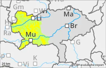
The avalanche risk is still moderate above around 1900 metres and low below. There is still a persistent weak layer problem. The avalanche prone locations are limited but still difficult to recognise. North and east-facing slopes will be blown in again with the south-westerly wind. The avalanche prone locations are mainly on north to east facing slopes above 1900 metres. Slab avalanches can still be triggered by individuals in some places. The slab can tear through to the layer close to the ground.
Snowpack
The snow cover tests carried out today (Friday) have shown that snow slabs can still be triggered on the north and east-facing slopes. The persistent weak layer problem is still present. Surface hoar, angular shapes or a hard old snowpack were covered. In the northern and eastern exposures, the old snowpack continues to be weakened by crusts and layers with faceted crystals and floating snow.
Tendency
Temperatures will plummet in the night to Sunday with a stormy north-westerly wind. There will be frequent snow showers in Upper Styria, most of them in the Northern Alps.
On Sunday, an increase in avalanche danger is expected in the northern Alps and in the Niedere Tauern.
Danger level
treeline
Avalanche Problem
Persistent weak layer
Treeline
Wind slab
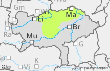
Low avalanche danger, but persistent weak layer problems in the northern and eastern exposures!
The avalanche risk is low. In the northern and eastern exposures, there is still a persistent weak layer problem at altitudes above the tree line. In steep terrain, avalanches can be triggered in a few places. Fresh wind slabs can also be triggered as snow slabs. However, even if the old snowpack is torn through, the avalanches usually remain small.
Snowpack
There is still significantly less snow than average. Some new fallen snow is covering surface hoar or angular forms on the north side. The foundation is still weak.
Tendency
Temperatures will plummet in the night to Sunday with a stormy north-westerly wind. There will be frequent snow showers in Upper Styria, most of them in the Northern Alps. An increase in avalanche risk is to be expected in the Northern Alps at the weekend!
Danger level
Avalanche Problem
Persistent weak layer
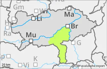
Low avalanche danger.
The avalanche risk is low. Small slab avalanches can be triggered in extremely steep gullies and bowls in isolated places at high altitudes.
Snowpack
There is still little snow. The snowpack is damp or crusted can form in places. In the higher elevations, angular snow crystals continue to weaken the stability on shady slopes.
Tendency
Temperatures will plummet in the night to Sunday with a stormy north-westerly wind. There will be frequent snow showers in Upper Styria, most of them in the northern Alps. The Koralpe will not get any significant new fallen snow. No significant change in the avalanche danger is expected.