Weak layers in persistent weak layers remain prone to triggering
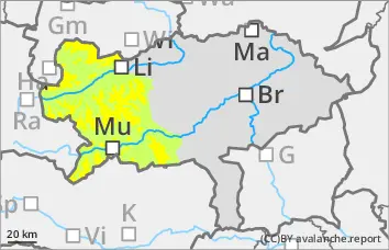
The avalanche risk is still moderate above around 1900 metres and low below. There is still a persistent weak layer problem. The avalanche prone locations are limited but still difficult to recognise. These are mainly on north to east facing slopes above 1900 metres. Here, slab avalanches can still be triggered by individuals in some places. With the sometimes strong wind, fresh wind slabs are forming in the northern Alps, which can be triggered as slabs.
Snowpack
The surface hoar, angular shapes or a hard old snowpack will be covered by wind slab and new fallen snow on Friday. However, large amounts of new snow are not yet expected. In the northern and eastern exposures, the old snowpack will continue to be weakened by crusts and layers with faceted crystals and floating snow; the persistent weak layer problem remains.
Tendency
On Saturday, clouds will rapidly gather again from the south-west, with rain and snow in the afternoon. A cold front with strong winds and a drop in temperature will follow in the night to Sunday.
The risk of avalanches is expected to increase at the weekend.
Danger level
treeline
Avalanche Problem
Persistent weak layer
Treeline
Wind slab
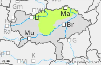
Low avalanche danger, but persistent weak layer problems in the northern and eastern exposures!
The avalanche risk is low. In the northern and eastern exposures, there is still a persistent weak layer problem at altitudes above the tree line. In steep terrain, avalanches can be triggered in a few places. Fresh wind slabs can also be triggered as snow slabs. However, even if the old snowpack is torn through, the avalanches usually remain small.
Snowpack
There is still significantly less snow than average. Some new fallen snow is covering surface hoar or angular forms on the north side. The foundation is still weak.
Tendency
On Saturday, clouds will rapidly gather again from the south-west, with rain and snow in the afternoon. A cold front with strong winds and a drop in temperature will follow in the night to Sunday. The avalanche risk is expected to increase at the weekend!
Danger level
Avalanche Problem
Persistent weak layer
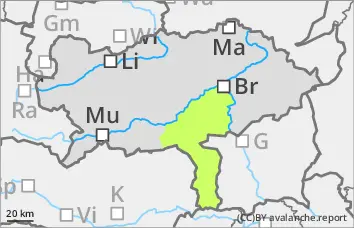
Low avalanche danger.
The avalanche danger remains low. Small slab avalanches can be triggered in extremely steep gullies and bowls in isolated places at high altitudes.
Snowpack
There is still little snow. The snowpack is damp or crusted can form in places. In the higher elevations, however, angular snow crystals are still weakening the stability on shady slopes. Above this, in the extended eastern sector, there may also be a thin, bound layer, which in some cases is not well bonded to the old snowpack.
Tendency
On Saturday, clouds will rapidly gather again from the south-west, with rain and snow in the afternoon. A cold front with strong winds and a drop in temperature will follow in the night to Sunday. An increase in avalanche risk is possible.