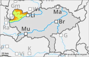
New fallen snow and wind slabs increase the avalanche danger!
The avalanche danger increases rapidly with altitude and is rated as considerable above approx. 1800 metres. The avalanche situation remains very delicate for alpinists. The persistent weak layer problem is still present and difficult to assess. In addition, fresh wind slab leads to an increase in avalanche danger. The avalanche prone locations are from north-west to east in terrain adjacent to ridgelines and at the entrances to gullies and bowls. Medium-sized slab avalanches can be triggered by individuals. It is very likely that avalanches will tear through to deeper layers.
Snowpack
Fresh wind slab overlays soft layers of faceted crystals and surface hoar. The persistent weak layer is weakened by the kinetic metamorphism. The wind slab falls cold and is brittle.
Tendency
Strong to stormy westerly winds will blow across the northern side of the Alps on Monday night as a warm front passes through. A few centimetres of new fallen snow may fall in the northern Limestone Alps. In the evening and during the night to Tuesday, a north-westerly weather pattern will set in, which will lead to renewed snowfall in the northern foothills. The considerable risk of avalanches remains.
Danger level
1900m
Avalanche Problem
Persistent weak layer
1900m
Wind slab
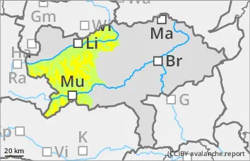
Fresh wind slab!
The avalanche risk is still moderate above around 1900 metres and low below. There is still a persistent weak layer problem. In addition, fresh wind slab is to be expected! The avalanche prone locations are limited but still difficult to recognise. The avalanche prone locations are mainly on north to east facing slopes above 1900 metres. Older wind slab snow is in the northern sector, fresh wind slab snow in the eastern sector. Slab avalanches can be triggered by individuals in a few places here. The slab can tear through to the layer close to the ground.
Snowpack
The persistent weak layer problem still exists. Surface hoar, angular forms or a hard old snowpack have been covered. In the northern and eastern exposures, the old snowpack continues to be weakened by crusts and layers with faceted crystals and floating snow.
Tendency
Strong to stormy westerly winds will blow across the northern side of the Alps on Monday night as a warm front passes through. A few centimetres of new fallen snow may fall in the northern Limestone Alps. Monday will be mostly free of precipitation during the day and the clouds will soften on the southern side of the Alps. In the evening and during the night on Tuesday, a north-westerly weather pattern will set in, resulting in renewed snowfall in the northern foothills. No significant change in the avalanche risk is expected.
Danger level
treeline
Avalanche Problem
Persistent weak layer
Treeline
Wind slab
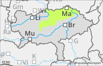
Low avalanche danger, but persistent weak layer problems in the northern and eastern exposures!
The avalanche risk is low. In the northern and eastern exposures, there is still a persistent weak layer problem at altitudes above the tree line. In steep terrain, avalanches can be triggered in a few places. Fresh wind slab snow is deposited in the Hochschwab area and can also be triggered as a snow slab. However, even if the old snowpack is torn through, the avalanches usually remain small.
Snowpack
Some new fallen snow covers surface hoar or angular shapes on the north side. The foundation is still weak.
Tendency
Strong to stormy westerly winds will blow across the northern side of the Alps on Monday night as a warm front passes through. A few centimetres of new fallen snow may fall in the northern Limestone Alps. Monday will be mostly free of precipitation during the day and the clouds will soften on the southern side of the Alps. In the evening and during the night on Tuesday, a north-westerly weather pattern will set in, resulting in renewed snowfall in the northern foothills. No significant change in the avalanche risk is expected.
Danger level
Avalanche Problem
Persistent weak layer
Low avalanche danger.
The avalanche risk is low. Small slab avalanches can be triggered in extremely steep gullies and bowls in isolated places at high altitudes.
Snowpack
There is still little snow. The snowpack is damp or crusted can form in places. In the higher elevations, angular snow crystals continue to weaken the stability on shady slopes.
Tendency
Strong to stormy westerly winds will blow across the northern side of the Alps on Monday night as a warm front passes through. A few centimetres of new fallen snow may fall in the northern Limestone Alps. Monday will be mostly free of precipitation during the day and the clouds will soften on the southern side of the Alps. In the evening and during the night on Tuesday, a north-westerly weather pattern will set in, resulting in renewed snowfall in the northern foothills. No new snowfall is expected in the south.