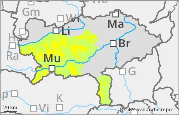
Persistent weak layer problem! Be especially careful in gullies and bowls in the northern and eastern sectors!
The avalanche risk is assessed as moderate above 1800 metres and low below that. The snow layering is still very weak, especially in the northern and eastern sectors. Here, avalanches can be triggered by even small additional loads and can reach medium size when breaking through the weak old snowpack. In some cases, there is a thin, bound layer from the last snowfall. The danger areas are mainly located in the transition from little to more snow as well as behind terrain edges and in the entrance area of gullies and bowls. Some of the danger spots are difficult to recognise.
Snowpack
The total snow depth is well below average. A thin layer of bound new fallen snow overlays a very variable old snowpack. There is significantly more snow in shady gullies and bowls than on sunny slopes, some of which are partly bare up to 2000 metres. In the northern and eastern exposures, the snowpack is still weakened by layers with faceted crystals and floating snow (persistent weak layer problem!).
Tendency
No change in the avalanche danger is expected.
The weather will temporarily improve on Monday, with bright and sunny leisure weather returning to the mountains. Tuesday will also bring intermittent sunshine, but the wind will pick up considerably. From today's perspective, Wednesday will be unsettled, with new fallen snow also possible.
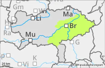
Danger level
Low avalanche danger with mostly little snow.
The avalanche risk is low. In extremely steep gullies or bowls on shady slopes above the tree line, the triggering of small slab avalanches between pillows of wind drifted snow, some of which are prone to triggering, and the persistent weak layer cannot be completely ruled out.
Snowpack
The overall snow depth is well below average. In the middle and higher elevations, there is a thin layer of partly bound new fallen snow on a regionally very varied old snowpack. Angular shapes weaken the snow layering in shady gullies and bowls.
Tendency
No change in the avalanche danger is expected.
The weather will temporarily improve on Monday, with bright and sunny leisure weather returning to the mountains. Tuesday will also bring intermittent sunshine, but the wind will pick up considerably. From today's perspective, Wednesday will be unsettled, with new fallen snow also possible.
Danger level
Avalanche Problem
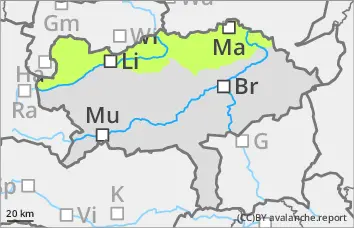
Persistent weak layer
Persistent weak layer problem in the northern and eastern sectors!
The avalanche risk is low. In the northern and eastern exposures, there is still a persistent weak layer problem at higher altitudes. In steep terrain, small slab avalanches can be triggered by individual winter sports enthusiasts. Avalanche prone locations are mainly adjacent to ridgelines and behind terrain edges. In general, the risk of being swept away, falling and injury outweighs the risk of burial. However, be careful in the area of terrain traps.
Snowpack
A thin, partly bound snowpack covers the mostly hardness of the old snowpack. This is weakened on shady slopes by kinetic metamorphism (persistent weak layer problem!). There are faceted crystals between crusts. There is still only a little snow.
Tendency
No change in the avalanche danger is expected.
The weather will temporarily improve on Monday, with bright and sunny leisure weather returning to the mountains. Tuesday will also bring intermittent sunshine, but the wind will pick up considerably. From today's perspective, Wednesday will be unsettled, with new fallen snow also possible.