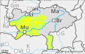
Persistent weak layer problem! Be especially careful in gullies and bowls in the northern and eastern sectors!
The avalanche risk is assessed as moderate above 1800 metres and low below that. The snow layering is still very weak, especially in the northern and eastern sectors. Here, avalanches can be triggered by even small additional loads and can reach medium size when breaking through the weak old snowpack. Above this, there are sometimes thin pillows of wind drifted snow from the last snowfall. The danger areas are mainly located in the transition from a little to a lot of snow as well as behind terrain edges and in the entrance area of gullies and bowls. The danger spots are often difficult to recognise.
Snowpack
On a very varied old snow surface, there are localised thin pillows of wind drifted snow that are prone to triggering. These are partly covered by soft new fallen snow. In the northern and eastern exposures, the snowpack is still weakened with faceted crystals and floating snow (persistent weak layer problem!). The overall snow depth is well below average.
Tendency
No change in the avalanche risk is expected.
The high pressure weather will remain in place for the next few days. From today's perspective, the next disturbance will reach us during Tuesday with the potential for some new fallen snow on Wednesday.
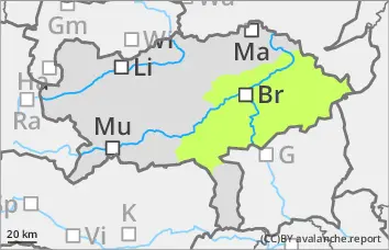
Danger level
Low avalanche danger with mostly little snow.
The avalanche risk is low. In extremely steep gullies or bowls on shady slopes above the tree line, the triggering of small slab avalanches between pillows of wind drifted snow, some of which are prone to triggering, and the persistent weak layer cannot be completely ruled out.
Snowpack
In the middle and higher elevations, new fallen snow has been deposited on an old snowpack that varies greatly from region to region. Angular shapes weaken the snow layering in shady gullies and bowls. In some places, grassy slopes were covered with snow again.
Tendency
No change in the avalanche risk is expected.
The high pressure weather will remain in place for the next few days. From today's perspective, the next disturbance will reach us during Tuesday with the potential for some new fallen snow on Wednesday.
Danger level
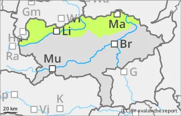
Avalanche Problem
Persistent weak layer
Persistent weak layer problem in the northern and eastern sectors!
The avalanche risk is low. In the northern and eastern exposures, there is still a persistent weak layer problem at higher altitudes. In steep terrain, small slab avalanches can be triggered by individual winter sports enthusiasts. In general, the risk of entrainment, falling and injury outweighs the risk of burial. However, be careful in the area of terrain traps.
Snowpack
A thin snowpack, sometimes also pillows of wind drifted snow, cover the mostly hard old snowpack. This is weakened on shady slopes by kinetic metamorphism (persistent weak layer problem!). There are faceted crystals between crusts. There is still only a little snow.
Tendency
No change in the avalanche risk is expected.
The high pressure weather will remain in place for the next few days. From today's perspective, the next disturbance will reach us during Tuesday with the potential for some new fallen snow on Wednesday.