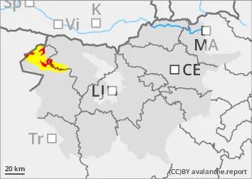
The current snowpack pattern is uncommon and requires special attention and caution!
New fallen snow has hidden old traps.
Even a small additional load can trigger a medium-sized avalanche near ridges and other typical leeward locations with blowing snow. Chain avalanches are also possible, where the triggering of a small clast of freshly blown snow causes the collapse of old Weak layers in the snowpack!
In some places, the additional load (blowing snow) will naturally trigger cluster avalanches.
Snowpack
dp.1: deep persistent weak layer dp.5: snowfall after a long period of cold
Up to 50 cm of snow fell over the weekend on a thin, old snow base, which was covered with a crust and cut in many places. The new fallen snow covered the old snowpack and did not bond well with it. The snow was blowing in a south to south-easterly wind. New snowdrift accumulations have formed, which naturally put additional stress on the old snow cover, which has deep, persistent weak layers. On Monday, the new fallen snow has become heavier, especially in the mid-mountains, and will freeze overnight.
Tendency
On Thursday, it will snow at first, with a chance of 20 to 30 cm of drier snow. The danger of avalanches will remain high.
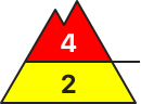
Danger level
treeline
Avalanche Problem
Persistent weak layer
Treeline
New snow
Treeline
Wind slab
Treeline
Gliding snow
1700m
The current snowpack pattern is uncommon and requires special attention and caution!
New fallen snow has hidden old traps.
Even a small additional load can trigger a medium-sized avalanche near ridges and other typical leeward locations with blowing snow. Chain avalanches are also possible, where the triggering of a small clast of freshly blown snow causes the collapse of old Weak layers in the snowpack!
In some places, the additional load (blowing snow) will naturally trigger cluster avalanches.
Snowpack
dp.1: deep persistent weak layer dp.5: snowfall after a long period of cold
Up to 50 cm of snow fell over the weekend on a thin, old snow base, which was covered with a crust and cut in many places. The new fallen snow covered the old snowpack and did not bond well with it. The snow was blowing in a south to south-easterly wind. New snowdrift accumulations have formed, which naturally put additional stress on the old snow cover, which has deep, persistent weak layers. On Monday, the new fallen snow has become heavier, especially in the mid-mountains, and will freeze overnight.
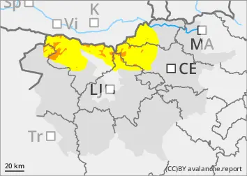
Tendency
The south-westerly wind will strengthen considerably on Tuesday afternoon and will be able to tolerate light snow! Showers will start to appear on Wednesday night. On Wednesday, we can expect heavier showers with wind! The snowfall level will be around 1300 m above altitudes. The danger of avalanches will increase rapidly during the day on Wednesday.
Danger level
1400m
Avalanche Problem
Wet snow
1400m
Gliding snow
1400m
New fallen snow, slush
Snowpack stability is poor, especially in new snowdrift accumulations at typical locations - along ridges, in ravines, etc. Here, a small additional load can trigger a medium-sized avalanche.
Snowpack
dp.3: rain
Around 50 cm of snow fell over 1500 m at the weekend on a thin, old snow base, which was covered with a crust and had many cuts. Where the snow fell on hard, frozen ground, it did not bond well with it. It snowed with a strong southerly wind, especially near the ridges, causing snowdrift accumulations. The snowpack became heavier during the day on Monday and will freeze overnight.
Tendency
Showers will start to appear on Wednesday night. On Wednesday, we expect heavier showers with wind! The snowfall level will start at around 1300 m above altitudes, rising to 1900 m during the day. The danger of avalanches will increase temporarily due to rain.
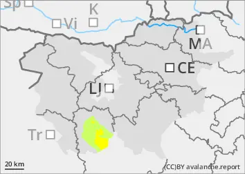
Danger level
1200m
Avalanche Problem
Wet snow
1200m
Gliding snow
1200m
More heavy precipitation, snow turning to rain
Even a small additional load can trigger a small avalanche, especially in typical leeward areas with freshly blown snow.
Snowpack
dp.3: rain
Up to 40 cm of new fallen snow has fallen on bare ground above 1300 m since Friday. Snowdrift accumulations have formed due to the strong southerly wind. In sunny weather, the snowpack has firmed up on Monday and is expected to freeze overnight.
Tendency
Showers will start to appear on Wednesday night. On Wednesday, we expect heavier showers with wind! The snowfall level will be around 1200 m above altitudes at first, rising to around 1500 m during the day. The danger of avalanches will increase temporarily due to rain.