The current snowpack pattern is uncommon and requires special attention and caution!
Heavy snow with wind
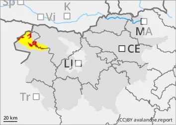
The danger of avalanches increases when it snows. New fallen snow has poor adhesion to the old base. Avalanches of dry snow will also occur spontaneously above the tree line, and can be large. This is particularly the case on northern slopes where weak layers are present in the old snow cover. At the time of the snowfall, moderate to strong southerly winds were blowing, transporting large amounts of light snow and building up new snow layers, especially in the high alpine regions. Altitudes are between 1700 and 1800 m, and weather conditions are such that snow or rain is falling. Gliding avalanches are possible.
Snowpack
dp.1: deep persistent weak layer dp.5: snowfall after a long period of cold
Rainfall intensified on Wednesday. Snowfall ranged from 20 to 40 cm, dry in the high alpine regions and increasingly wet below about 1700 m. There were moderate to strong southerly winds, which built up in large areas. Deep and persistent weak layers are present in the old snow cover. The snowpack is unstable in many places. Another 10 to 20 cm of snow will fall by Thursday evening.
Tendency
Friday looks dry, with clouds breaking up. The danger of Avalanches will remain similar.
Danger level
treeline
Avalanche Problem
Persistent weak layer
Treeline
New snow
Treeline
Wind slab
Treeline
Gliding snow
1700m
The current snowpack pattern is uncommon and requires special attention and caution!
Heavy snow with wind
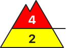
The danger of avalanches increases when it snows. New fallen snow has poor adhesion to the old base. Avalanches of dry snow will also occur spontaneously above the tree line, and can be large. This is particularly the case on northern slopes where weak layers are present in the old snow cover. At the time of the snowfall, moderate to strong southerly winds were blowing, transporting large amounts of light snow and building up new snow layers, especially in the high alpine regions. Altitudes of 1700 m or higher are seeing weather that involves snow or rain, and there is a possibility of gliding avalanches.
Snowpack
dp.1: deep persistent weak layer dp.5: snowfall after a long period of cold
Rainfall intensified on Wednesday. By the evening, 10 to 30 cm of snow had fallen, dry in the high alpine regions and increasingly wet below about 1700 m. There were moderate to strong southerly winds, which built up in large areas. Deep and persistent weak layers are present in the old snow cover. The snowpack is unstable in many places. Another 10 to 20 cm of snow will fall by Thursday evening.
Tendency
Friday looks dry, with clouds breaking up. The danger of avalanches will remain similar.
Danger level
1200m
Avalanche Problem
Wet snow
1200m
Gliding snow
1200m
More heavy precipitation, rain turning to snow
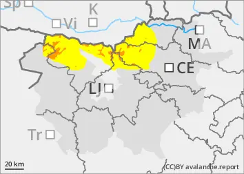
Isolated wet snow avalanches will still be possible due to the thawing rain. The danger will be higher, especially on steep grassy slopes.
Snowpack
dp.4: cold following warm / warm following cold
The snowpack has become heavier as the weather warms up. The snowfall level was around 800 m above altitudes on Wednesday morning, but rose rapidly during the day. During the night of Thursday, the snowfall level will drop again to around 1000 m above altitudes. Up to 10 cm of more or less wet snow may fall.
Tendency
As the weather gradually cools, the danger of avalanches will decrease.
Danger level
1400m
Avalanche Problem
Wet snow
1400m
Gliding snow
1400m
More heavy precipitation, rain turning to snow
Isolated wet snow avalanches will still be possible due to the thawing rain. The danger will be higher, especially on steep slopes.
Snowpack
dp.4: cold following warm / warm following cold
The snowpack has become heavier as the weather warms up. The snowfall level was around 1200 m above altitudes on Wednesday morning, but rose rapidly during the day. The snowfall level is expected to drop back down to around 1200 m during the night of Thursday. A few centimetres of southern snow may fall.
Tendency
As the weather gradually cools, the danger of avalanches will decrease.