Danger level
 | treeline |
|  |
|  |

![]()
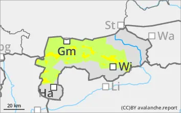
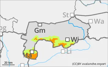
Fresh wind slab is prone to triggering and must be observed!
The avalanche risk is classified as considerable, mainly at higher altitudes, in some cases above the tree line. Attention should be paid to freshly filled steep slopes adjacent to the ridgeline as well as steep bowls and gullies, especially in the eastern sector and on the south side. Medium slab avalanches could be triggered here by even a small additional load. These avalanche-prone locations must be avoided at all costs. Depending on the amount of new snow, small loose snow avalanches are possible on very steep, extreme terrain in the afternoon when the sun is shining.
Snowpack
The latest new fallen snow (especially from Sunday night) is being transported by predominantly strong winds from the west to northwest and is not binding well with the old snowpack, which is sometimes soft or icy on the surface. The more extensive snowdrift accumulations at higher elevations are very prone to triggering. Crystals that have been transformed as they build up weaken the snow base, fundament. The snow depths are distributed very differently, alternating between blown away areas and areas filled with wind slab.
Tendency
No significant change. However, significant warming on Monday leads to settlement of the snow cover, snowpack.