The danger of Avalanche is low. Be careful in fresh snowdrift accumulations!
The snowpack is mostly stable. In some places in the High alpine regions, especially on fresh snowdrift accumulations of blown snow, a small, clustered Avalanche can be triggered under higher loads.
Snowpack
dp.4: cold following warm / warm following cold
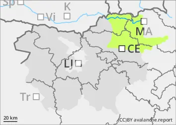
There is little snow, and the peaks and ridges are in some places blown bare. During the last deterioration, about 10 cm of New fallen snow fell, on Sunny slope below 2000 m on terrestrial ground.
In the high alpine regions, weak layers may be present in the old snow cover.
Tendency
Monday and Tuesday will be sunny and warmer, with zero isotherm above 2500 m. Winds will die down.
Danger level
Avalanche Problem
Wet snow
Wind slab
Treeline
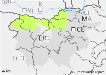
Up to 40 cm of snow in some places, don't walk alone on steep meadows!
On steep meadows with blowing snow, an Avalanche can be triggered. As the weather clears and gradually thaws, the snow will become heavier, especially in the afternoon, and spontaneous creeps of wet snow will break out.
Snowpack
dp.6: cold, loose snow and wind
Up to 40 cm of snow fell on the ground in Kobansko and 30 cm in Pohorje. Snowdrift accumulations have formed on the edges of meadows and near Ridge due to strong NE winds. On Saturday during the day, snow on the Sunny slope over low clouds became heavier, while during the night a thin drizzle formed.
Tendency
Winds will weaken overnight on Monday. Monday and Tuesday will be sunny and warmer. The danger of avalanches will decrease.